Approximate Location Map
Large Map »
Latitude: 51.4429 / 51°26'34"N
Longitude: 0.3821 / 0°22'55"E
OS Eastings: 565644
OS Northings: 174238
OS Grid: TQ656742
Mapcode National: GBR NML.FFP
Mapcode Global: VHJLC.KZVR
Plus Code: 9F32C9VJ+5R
Entry Name: Barrelled Lock Chamber, Sea Walls, Swing Bridge, Locks and Canal Basin
Listing Date: 17 September 2010
Grade: II
Source: Historic England
Source ID: 1393973
English Heritage Legacy ID: 508409
ID on this website: 101393973
Location: Milton, Gravesham, Kent, DA12
County: Kent
District: Gravesham
Electoral Ward/Division: Riverside
Parish: Non Civil Parish
Built-Up Area: Gravesend
Traditional County: Kent
Lieutenancy Area (Ceremonial County): Kent
Church of England Parish: Milton St Peter and St Paul
Church of England Diocese: Rochester
742/0/10021 GORDON PROMENADE EAST
17-SEP-10 Barrelled lock chamber, sea walls, swi
ng bridge, locks and canal basin
II
Canal basin, lock chamber, sea wall, locks and swing bridge. 1799-1801 sea wall, lock chamber and canal basin, designed by civil engineer Ralph Dodd. Late-C19 swing bridge and probably C20 lock gates. The late-C20 wooden panelling to part of the western side of the northern part of the canal basin is not included, nor is the late-C20 concrete sheet piling to the western section of the south side of the canal basin, to the western side of the canal basin and part of the western side of the north side of the canal basin.
MATERIALS
Walls mainly of yellow and brown brick in English bond with deep York stone coping and quoins, in places patched with C20 engineering bricks. The canal basin is reported to have a paved floor. The swing bridge, lock gates and their mechanisms are of cast-iron. There is a wooden floor to the swing bridge and wooden lock gates.
DESCRIPTION
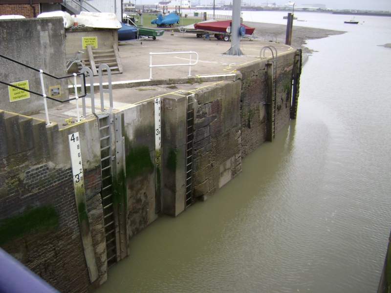
The River Thames frontage has curved sea walls which lead directly into the barrelled lock chamber, unusual because it has a curved shape, partly to match the shape of ships hulls. The north west side wall has a series of Roman numerals by the locks to indicate the water depth. The extreme north of the north eastern side of the lock chamber has been strengthened in late-C20 concrete and sheet piling. The swing bridge at the northern end is a cast-iron riveted structure with flat arch and cast-iron handrail, still operated by a circular cast-iron winch on a three-legged pedestal. The northern lock gates were blown off by enemy action during the Second World War and not replaced. The southern lock gates comprises two panelled wooden gates, probably of C20 date, with a cast-iron walkway above with painted cast-iron balustrading. They are operated by four winches with intact mechanism in cast-iron housing.
The lock basin south end leads into the canal basin, with a section of curved and battered brick walling with stone coping to the west. To the east it curves into the north eastern wall of the canal basin and becomes a straight battered section constructed of brick with stone coping. At the eastern end it curves into what was originally a lock between the lock basin and the canal, which has now been blocked off. This former entrance to the canal forms the eastern side of the canal basin, which is curved on both the north and south sides, and retains on each side the curved stone slot to the original lock gates and cast iron remains of the opening mechanism. The eastern side of the south side of the canal basin is a straight section angled to the south-east with a number of iron mooring rings in the stone coping. With the exception of a small section of the western side of the north side of the canal basin of brick walling, forming the southern entrance to the lock basin the remainder of the canal basin was simply dug out of the chalk and had no brick or masonry walls.
HISTORY
Work on the canal basin of the Thames and Medway Canal commenced in 1799 during the wars with Revolutionary, and later, Napoleonic France. The canal was originally designed to provide a safe route for ships and barges from the Deptford and Woolwich Dockyards supplying ordnance to men-of-war lying at Chatham, avoiding the considerable danger from French privateers operating in the Thames estuary. A further advantage was that ships would be saved the 47 mile passage around the Isle of Grain, which would be reduced to just over six miles. A civil engineer, Ralph Dodd, published a pamphlet in 1799 advocating a six-mile canal between Gravesend and Chatham with locks and basins. He estimated that it would take two years to build and cost £24,576. Part of the cost was to be defrayed by selling the excavated chalk as agricultural lime. Dodd considered that the canal would not only be useful to the government but would also attract commercial vessels. In 1800 the canal company received the necessary Act of Parliament and work began at the Gravesend end. The estimated cost had by then reached £57,433.
From the Gravesend basin the canal began with a straight section aligned with New Tavern Fort, Gravesend. By 1801, four miles had been constructed as far as Higham. A new engineer, Ralph Walker, announced that the whole canal would cost much more than the revised estimate. Work was stopped and by 1804 Richard Dodd had probably left the project. Over the next few years Walker suggested two new routes for the Higham to Strood stretch for which Acts of Parliament were obtained and money raised. The approved route required a tunnel through the chalk hills 3946 yards long. Work on this did not start until 1819 and it was designed by William Tierney Clark. The Higham Tunnel was over 26 feet wide and was 35 feet high. It was the second longest canal tunnel built in Britain but had the largest cross section. The canal finally opened on 14 October 1824, completed by W T Clark, but by that time the Revolutionary and Napoleonic wars were long over and the military need had greatly diminished. The canal had taken five acts of Parliament and cost about £260,000.
Despite a steady trade of agricultural products, beer, cement and groceries, the canal was never a financial success and there were technical problems because the canal walls leaked and the water level dropped every spring tide. In February 1844 the company built a single track railway alongside the canal which was brought through the Higham Tunnel, supported on timbers over the water. Eighteen months later the Higham Tunnel was sold to the South Eastern Railway, who filled in the canal from Higham to Frindsbury. The stretch of canal from Gravesend to Lower Higham was navigable into the 1930s but officially abandoned in 1934. In World War II some of London's bomb rubble was brought in to in-fill parts of the canal and the outer lock gate of the lock chamber was blown off by enemy action. The canal has mostly been filled-in apart from the Gravesend canal basin and a small section downstream between it and the Higham Tunnel.
The 1874 Ordnance Survey map shows the canal basin to its present extent with shaded lines to the western part of the north side, west side and western part of the south side, indicating chalk excavation edges rather than brick and masonry edges. A drawbridge is shown passing over the lock basin to the north of the canal basin, which is shown with two locks. A further lock with lock gates is shown at the eastern end of the canal basin where it entered the canal. The only change recorded on the 1897 Ordnance Survey sheet is that the drawbridge over the lock chamber is now called a swing bridge, and this change is repeated on the 1909 and 1936 maps.
SOURCES
Chrimes, M, Oxford DNB article on Ralph Dodd.
http://www.medwaylines.com/thamesand medwaycanal.htm Accessed 23/06/10.
Vine, P, A, L, 'Kent and East Sussex Waterways', Middleton Press (1989)
REASONS FOR DESIGNATION
The 1799-1801 sea walls, lock chamber and canal basin, and probably late-C19 swing bridge of the Thames and Medway Canal are designated at Grade II for the following principal reasons:
* Historical and technological significance: this is the only currently navigable part of the Thames and Medway Canal, originally designed to protect supplies to the English navy from French privateers during the Napoleonic wars. The lock basin has unusual curved rather than straight sides. The late-C19 operating mechanism of the swing bridge and lock gates is still in use.
* Architectural interest: the 1799-1801 brick walls with York stone coping and quoins bearing incised Roam numerals indicating the canal depth is handsome and robust, as well as early in date.
* Intactness: the sea walls, lock chamber and canal basin walls are mainly of original fabric, except where patched for repairs.
* Rarity: the Thames and Medway Canal was one of very few canals constructed in the counties south of London.
Yes, list at Grade II.
External links are from the relevant listing authority and, where applicable, Wikidata. Wikidata IDs may be related buildings as well as this specific building. If you want to add or update a link, you will need to do so by editing the Wikidata entry.


Other nearby listed buildings
