Approximate Location Map
Large Map »
Latitude: 51.377 / 51°22'37"N
Longitude: -2.3563 / 2°21'22"W
OS Eastings: 375296
OS Northings: 164281
OS Grid: ST752642
Mapcode National: GBR 0QH.R2B
Mapcode Global: VH96M.3NN7
Plus Code: 9C3V9JGV+RF
Entry Name: Halfpenny Bridge and Lodge House
Listing Date: 29 October 1987
Last Amended: 15 October 2010
Grade: II
Source: Historic England
Source ID: 1394582
English Heritage Legacy ID: 509978
Also known as: Widcombe Bridge
Widcombe Footbridge
Dolemeads Bridge
ID on this website: 101394582
Location: Lyncombe Hill, Bath and North East Somerset, Somerset, BA2
County: Bath and North East Somerset
Parish: Non Civil Parish
Built-Up Area: Bath
Traditional County: Somerset
Lieutenancy Area (Ceremonial County): Somerset
Tagged with: Bridge Footbridge
CLAVERTON STREET
(North side)
Halfpenny Bridge and Lodge House
29/10/87
II
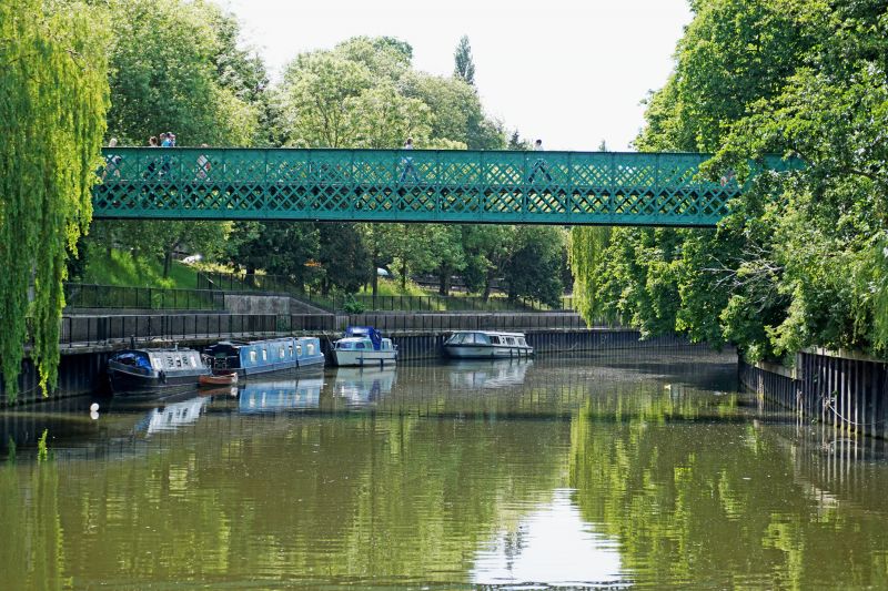
Pedestrian bridge with tollhouse. Toll House 1862. Bridge dated 1877.
MATERIALS: Bridge in steel with limestone ashlar abutments, tollhouse limestone ashlar with slate roof.
EXTERIOR: bridge is riveted steel girder with steel lattice balustrade, set to stone revetments, ashlar faced towards river, coursed rubble to approach ramps built out from steep bank at either side. At three positions on bridge lettered plate recording: "Westwood Baillie and Company, Contractors, Poplar, London. T.E.M. Marsh Esq Engineer 1877." Footway macadamised. Toll house has small tower like structure on three levels, one room at each, top level has panelled door and blocked opening to east facing footway, south side one small blocked opening, to west blocked opening at middle level, and to river (north) blocked doorway at tow path level and small blocked opening at top level. Roof hipped, with cut stone hips and ridge ashlar stack with three flues to south west corner. Various steel channel or flat strappings. River face has a series of incised dates recording flood levels between 1866 and 1960; the highest of these levels shown as November 15th 1894.
HISTORY: The first footbridge was built here in 1863, connecting Widcombe with the city. A 100ft wide bow string trussed bridge in timber, designed by Hicks & Isaacs, it collapsed spectacularly in June 1877 as a result of overloading: hundreds of visitors to the Bath and West Show were standing on the bridge waiting to pay their toll on the southern side. This led to the deaths of eight people, and a high number of injuries. The replacement bridge was rapidly erected in a more stable steel box girder structure, using the same piers as the earlier bridge. Marsh had earlier conducted the inquiry into the collapse.
SOURCE: M. Scott, Discovering Widcombe & Lyncombe (2nd ed 1993), 61-65.
Listing NGR: ST7529664281
External links are from the relevant listing authority and, where applicable, Wikidata. Wikidata IDs may be related buildings as well as this specific building. If you want to add or update a link, you will need to do so by editing the Wikidata entry.


Other nearby listed buildings
