Approximate Location Map
Large Map »
Latitude: 51.3869 / 51°23'12"N
Longitude: -2.3602 / 2°21'36"W
OS Eastings: 375033
OS Northings: 165383
OS Grid: ST750653
Mapcode National: GBR 0Q9.XTQ
Mapcode Global: VH96M.1DMM
Plus Code: 9C3V9JPQ+QW
Entry Name: 11, Vineyards
Listing Date: 12 June 1950
Last Amended: 15 October 2010
Grade: II
Source: Historic England
Source ID: 1395506
English Heritage Legacy ID: 510913
ID on this website: 101395506
Location: Walcot, Bath and North East Somerset, Somerset, BA1
County: Bath and North East Somerset
Parish: Non Civil Parish
Built-Up Area: Bath
Traditional County: Somerset
Lieutenancy Area (Ceremonial County): Somerset
Tagged with: Building
This list entry was subject to a Minor Amendment on 19 August 2021 to amend a date, correct sentence in description and to reformat the text to current standards
656-1/31/1763
VINEYARDS
No.11
(Formerly Listed as THE VINEYARDS, Nos.11-19 (Consec))
12/06/50
GV
II
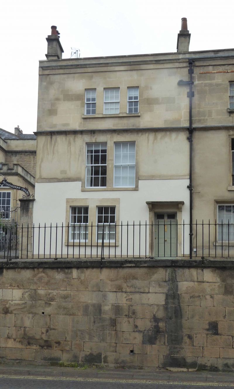
House. c1765-1775, raised C19. Developed by Thomas Omer.
MATERIALS: render and ashlar to front, ashlar to rear, parapeted roof, double pile to left with catslide to rear right, covering not visible to front, double Romans and pantiles to rear, coped gable wall to left with two ashlar stacks with some early clay pots. Staircase to rear.
EXTERIOR: three storey, two-window front. First floor has two two/two horned sashes in plain reveals with continuous lowered stone sill, second floor has three grouped four/four, six/six, four/four sashes in plain reveals with continuous stone sill. Ground floor has to left two boarded up windows in plain reveals with continuous stone sill, to right boarded up door in flat surround with unmoulded hood on shaped brackets. Plinth, former first floor sill band now cut through by windows; coved probable former eaves cornice over. First floor, frieze, moulded eaves cornice and coped parapet continuous with No.12 Vineyards (qv). Lead hopperhead and part-lead downpipe to right shared with No.12 Vineyards. Rear elevation partially visible has one and two-storey extensions, six/six sash to second floor.
INTERIOR: not inspected.
HISTORY: built on land formerly the property of Hayne family from 1638 when Thomas Hayne bought it from William Snygge; passed by inheritance to Charles Hayne 1750 who cleared it of a mortgage and other encumbrances; in 1755 plans to sell Vineyards to Thomas Omer for building reached advanced stage but not finally realised until indenture of 26 February 1755, Charles Hayne to Thomas Omer, Gent, and Thomas Jelly, Carpenter his trustee, sold Vineyards for building at yearly rent of £50. Belmont constructed on west edge of same ground.
The plot on which the present Vineyards terrace is built is referred to by the name ‘Vineyards’ (or similar archaic variants) throughout its documented history, though it is uncertain when its use for growing vines ceased. Row to north of Countess of Huntingdon's Chapel originally called Harlequin Row because of unusual use of brick and stone in construction. No.11 was occupied by the Deaf and Dumb House in 1871.
Listing NGR: ST7503365383
External links are from the relevant listing authority and, where applicable, Wikidata. Wikidata IDs may be related buildings as well as this specific building. If you want to add or update a link, you will need to do so by editing the Wikidata entry.


Other nearby listed buildings
