Approximate Location Map
Large Map »
Latitude: 51.5373 / 51°32'14"N
Longitude: -0.0436 / 0°2'36"W
OS Eastings: 535785
OS Northings: 183863
OS Grid: TQ357838
Mapcode National: GBR J7.ZMP
Mapcode Global: VHGQV.6MBB
Plus Code: 9C3XGXP4+WH
Entry Name: Lauriston Road Jewish Cemetery, the lodge, gates and piers facing Lauriston Road and portion of the walling to the south of the graveyard
Listing Date: 16 March 2021
Grade: II
Source: Historic England
Source ID: 1472497
ID on this website: 101472497
Location: South Hackney, Hackney, London, E9
County: London
District: Hackney
Electoral Ward/Division: Victoria
Parish: Non Civil Parish
Built-Up Area: Hackney
Traditional County: Middlesex
Lieutenancy Area (Ceremonial County): Greater London
Tagged with: Cemetery Jewish cemetery
A Jewish cemetery, which received its first burial in 1788 and was extended in 1852 and has a lodge building, walls, railings and gates of 1870 by HH Collins.
A Jewish cemetery, which received its first burial in 1788 and was extended in 1852 and has a lodge building, walls, railings and gates of 1870 by HH Collins.
MATERIALS: boundary walls are of early-C19, later-C19 and C20 brick and rendered brick with two portions of wooden fencing. The lodge is of Flemish bond brick with a slate roof and painted stone and timber dressings and the low western wall is of brick, supporting cast iron railings and gates.
PLAN: the cemetery covers slightly less than acre and is approximately rectangular in shape. The entrance and lodge are at the western end, with the lodge positioned in the north-western corner. A central drive runs eastwards from the western entrance, but is overlain by some graves and dies out as it runs eastwards, roughly half way along the length of the plot. The site of the demolished ohel now forms part of the driveway at its western end. There is no formal plan or layout to the cemetery other than this. The burial area contains straight rows of graves, all facing towards the western entrance, in grassy plots. London plane trees are grouped at the western end and the southern side.
Walling to the southern side at its eastern end appears to be of C18 or early-C19 date and is built of London stock brick laid in Flemish bond with a coping of bricks laid in soldier courses. This walling has a series of square stones inset which carry inscribed numbers indicating grave rows. These start at the eastern end with ‘7’ and continue until ‘15’ which is inset into a buttress. Other walling appears to be later, including C20 walls which form parts of buildings to the eastern side (number 9, Louisa Close) and north (9 and 10, Shafton Road).
Tombstones are grouped at the northern and eastern areas where synagogue members were buried. The earlier burials are at the eastern end. The western area has smaller headstones or unmarked graves and this is the ‘strangers’ section, where those who were not paid-up members of the synagogue were buried, including paupers who could not pay for their own burial. The earliest grave markers are relatively modest headstones with round or shouldered heads of Portland stone or Ketlin stone. Later stones are of Yorkshire or Cumberland stone, with some slate examples.
Burial in family groups was rare before the mid-C19. To the northern side of the central path is a grouping of impressive, mid-C19 monuments to member of the Jones family, which all date from after 1852. These start with a pair of Portland stone monuments, of 1852 and 1856, square on plan, with Corinthian columns to their corners and draped urns as finials. Following in a line extending to the west of these are four granite sarcophagi, standing on plinths and carved lion’s feet with a granite obelisk at their centre. All of these Jones monuments are surrounded by iron railings including flame finials and cross bars with a rope pattern. Elsewhere, C19 tombs include chest and ledger tombs. Inscriptions are generally in Hebrew for earlier tombs with a greater use of English appearing later. Symbols include hands raised in blessing of the Cohanim, crowns indicating a virtuous life and felled trees for a life cut short. Lettering is carved and occasionally filled with lead after the mid-C19.
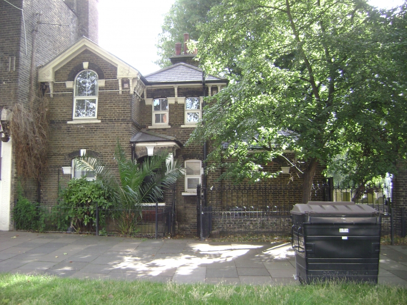
The Lodge, walls, railings and gates at the western end appear all to have been built at one date. The lodge is placed at the northern end. Its entrance front has painted stone and brindle brick dressings and carved timber brackets at eaves level. All windows have been replaced by uPVC substitutes. A projecting wing at left has a segmental head to the window at ground-floor level and an arch-headed window projecting up into the gable of the first floor. To the right of this are two bays with cambered heads to both floors. In the re-entrant angle is a porch with hipped roof. At right again and slightly recessed is a single-storey bay with hipped roof. This formerly had a doorway at its centre, but this has now been removed and bricked up, with the exception of the keystone and springers of the arched door head which remain. The southern flank of this single-storey range has three windows with cambered heads. The rear has a blocked window and doorway to the far left in the walling of the single-storey portion. At right of this the two-storey portion has a doorway flanked by windows at ground floor left and a single window to its right. At first-floor level are two windows with flat heads and above are twinned gables. Attached to the southern side of the entrance porch on the western, entrance front is low brick walling supporting cast iron railings and gates with brick piers. The piers are square on plan and have stone caps with pyramidal tops. The central drive gates are flanked by a pedestrian gate to each side. All have dog bars to their lower body and individual panels have arched tops with spear heads. The runs of railings at either side sit on low walls with cast iron coping panels.
Following the expulsion of Jews from England by Edward I in 1290, there were officially no Jewish communities in the country for over 300 years. From 1656 Oliver Cromwell informally allowed Jews to return, motivated by the financial benefits their trading connections would bring and a belief that their conversion to Christianity was essential before Christ would return to reign on earth. The initial settlers were Sephardi merchants of Spanish and Portuguese descent, who came via Holland where they had found sanctuary from religious persecution. Most lived and worked in London’s East End. The Sephardim were soon joined by Ashkenazi Jews from Germany and Holland, who established a synagogue as early as 1692 in Broad Street, Mitre Square, and thirty years later moved to the ‘Great Shul’ (Great Synagogue), a more spacious building in Duke’s Place.
The Hambro’ was an offshoot of the Great Synagogue, founded by a wealthy gem dealer - Marcus (or Mordecai) Moses - from Hamburg. He established a small house of study and prayer (beth hamedrash) in a house in St Mary Axe. It was bitterly opposed by the Great Synagogue and escalating disputes led to his excommunication by the Chief Rabbi of the Great Synagogue. In 1707 he formed a new congregation meeting in his home in Magpie Alley, Fenchurch Street. Jochanan Höllischau from Hamburg was engaged as the new congregation’s rabbi and he dissolved the decree of excommunication. In 1725 a synagogue was built in a garden next to Moses’s home in Magpie Alley. Conforming to the Hamburg minhag (customs) the synagogue was thus named the ‘Hambro’ (see SOURCES, Shulman 2006).
In the meantime, branch synagogues of the Great Shul were established at Bayswater (1863) and North London (1868). In 1870 the Hambro and the New Synagogues also joined the group, forming the United Synagogue. By about 1880, around 5,000 Jews had moved out of the centre of London to Hackney, Dalston and neighbouring parts of Islington. The more prosperous moved further north to Stamford Hill, Highbury and Stoke Newington, while south Hackney received overspill from Stepney and Bethnal Green (Baker 1995). In 1892-3 the Hambro synagogue building was demolished as part of the City of London improvements, but in 1899 a new building opened in Union Street, Whitechapel. This closed in 1936 when the congregation re-merged with the Great Synagogue after over 200 years apart (Shulman 2006).
The first burial ground of the Hambro’ was opened in 1707, in Hoxton Street, and remained in use officially until 1878. However, no interments took place for many years before that date and it no longer survives (International Jewish Cemeteries Project). In 1786 land east of Groves Road (now Lauriston Road) was sold to Leon Gompertz and other Ashkenazim acting for the ‘Germans’ Hambro Synagogue’. The land included a building, once part of that occupied by Sarah Tyssen (d 1779) widow of Samuel (Baker 1995). R Yehiel Preger was the first person to be buried in the cemetery, in February 1788, and his widow was laid to rest next to him ten years later. At the time of the cemetery’s foundation Hackney served as a rural retreat and the surrounding area was largely undeveloped. It remained so until the 1850s, when railway construction connected it to the city of London.
The cemetery was extended to the front in 1852 (see SOURCES, Kadish 2015, 35) but not long afterwards it had become dilapidated and its ohel was in a particularly poor state. In 1870 a major overhaul of the cemetery took place, funded by Mrs Flatou who paid £1,200 for its total renovation in memory of her late husband Louis Victor Flatou. A report in the Jewish Chronicle, (18 March 1870) provides a full description of the work done, which included partial re-building of the ohel in Italianate style by architect HH Collins. Semi-circular stained glass windows were fitted in the building, large iron gates and railings were placed at the cemetery entrance and the boundary walls were repaired. The grounds were tidied, tombs renovated, new paths made and trees and shrubs planted (see SOURCES, Kadish 2015, 35; and Roberts).
In 1886 an order was given by the Queen in Council at Osborne for the discontinuance of burials in some London parishes. Among the places listed for closure was ‘South Hackney Jews’ Burial Ground, Lauriston Road’. The order stated that burial should cease ‘forthwith and entirely in the Jewish Burial Ground except as follows: In such reserved grave spaces in the burial ground (as have never been buried in and which when opened are free from water) burials may be allowed if so many members of the families to whom they have been allotted as can be buried at or below the depth of 5 feet’. It also concluded that the cemetery had been voluntarily closed for some years (Jewish Chronicle, 13 August 1886). Despite the recent renovation work, the disused ohel was also demolished, in 1885.
Consent was granted for the construction of a small synagogue inside the gates in 2017 but this has not been acted upon. The lodge building has been used as accommodation and as a doctors' surgery. It is now (2021) used as offices.
Lauriston Road Jewish Cemetery, Hackney is listed at Grade II for the following principal reasons:
Architectural interest:
* the graveyard combines C18 and C19 headstones with C19 monuments and a grouping of later-C19 lodge, walls, railings and gates which show the development of Jewish burial customs and the assimilation of the community into British society. The grouping of lodge, gates and railings designed by HH Collins are a rare survival in this context and all have distinct architectural presence and the central group of monuments, complete with its iron railings is well preserved.
Historic interest:
* the Lauriston Road burial ground, established in 1786 was the first Jewish cemetery site in London to be laid out in a rural setting, beyond the initial cluster around Whitechapel.
Group value:
* it has group value with the Registered landscape of Victoria Park (Grade II*) and the K2 Telephone Kiosk outside the Adult Education Centre, Lauriston Road (Grade II).
External links are from the relevant listing authority and, where applicable, Wikidata. Wikidata IDs may be related buildings as well as this specific building. If you want to add or update a link, you will need to do so by editing the Wikidata entry.


Other nearby listed buildings