Approximate Location Map
Large Map »
Latitude: 50.623 / 50°37'22"N
Longitude: -2.1687 / 2°10'7"W
OS Eastings: 388159
OS Northings: 80377
OS Grid: SY881803
Mapcode National: GBR 225.Y85
Mapcode Global: FRA 67BF.BWY
Plus Code: 9C2VJRFJ+5G
Entry Name: Drinking fountain, 17m south-east of the Church of St Mary
Listing Date: 17 December 2020
Grade: II
Source: Historic England
Source ID: 1473377
ID on this website: 101473377
Location: Tyneham, Dorset, BH20
County: Dorset
Civil Parish: East Lulworth
Traditional County: Dorset
Lieutenancy Area (Ceremonial County): Dorset
Tagged with: Drinking fountain
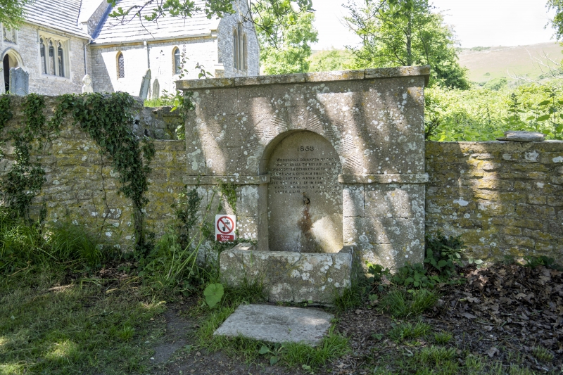
Drinking fountain, constructed in 1853.
Drinking fountain, constructed in 1853.
MATERIALS
It is constructed of limestone ashlar.
DESCRIPTION
The fountain is a rectangular structure with flat coping stones and a plinth, and its upper section has been built over a pre-existing boundary wall. It has a central recess with semi-circular head and tooled voussoirs, an impost string course and a projecting, rectangular stone trough. The rear wall of the recess has a tap, perhaps replacing a spout, and an inscription in black lettering which reads: 1853 / WHOSOEVER DRINKETH OF THIS / WATER SHALL THIRST AGAIN; BUT / WHOSOEVER DRINKETH OF THE WATER / THAT I SHALL GIVE HIM SHALL NEVER / THIRST; BUT THE WATER THAT I SHALL/ GIVE HIM SHALL BE IN HIM A WELL OF / WATER SPRINGING UP INTO EVER / LASTING LIFE. JOHN 4th 13 & 14.
Pursuant to s1 (5A) of the Planning (Listed Buildings and Conservation Areas) Act 1990 (‘the Act’) it is declared that the boundary wall the drinking fountain is built against is not of special architectural or historic interest and is excluded from the listing.
Tyneham, an abandoned or ‘ghost’ village is situated in a broad wooded valley to the south of the Purbeck Hills. The settlement has medieval origins and is recorded as Tigeham in the Domesday Book. Lawyer and Member of Parliament Nathaniel Bond acquired the manor of Tyneham in 1683 and then bought Creech Grange (also known as Grange) to the north-east which became the family’s principal residence. He bought out his brothers' interest in their father’s estate and settled Tyneham on his younger son John. In the mid-C18 his son and namesake succeeded him at Tyneham and later inherited Creech Grange from his uncle. The Bonds remained landowners of Tyneham throughout the C18 and C19, and Tyneham House to the east of the village was occupied over the years by members of the Bond family.
The drinking fountain at the north end of the village and close to the Church of St Mary (Grade II) was erected in 1853, probably by the Reverend Nathaniel Bond who was also responsible for building Tyneham's school (Grade II).
In 1917 the Royal Armoured Corps Gunnery School was established at Lulworth Camp with a firing range close to Tyneham. Military training increased in the run up to the Second World War, and in December 1943 the village and nearby hamlets and farms, comprising some 7,500 acres, were requisitioned by the War Office to expand the gunnery range. All local inhabitants were required to leave, displacing more than 200 people. The requisition was intended to be temporary, but after the war the military occupation of the area was considered still necessary. In 1948 the land was compulsorily purchased by the War Office. Since 1975 the public has been able to visit Tyneham and the surrounding area on approximately 145 days of the year when the military range is not in use.
The drinking fountain at Tyneham which was erected in 1853 is listed at Grade II for the following principal reasons:
Architectural interest:
* for its high-quality craftsmanship and materials and restrained classical styling.
Historic interest:
* as evidence of a donation to the village by the local landowner, demonstrating a growing awareness of the importance of public health and the type of philanthropy popular during the Victorian period;
* it is a good example of a type of public utility that were once common features of towns and villages and are now becoming increasingly rare.
Group value:
* it is prominently sited adjacent to the Grade II-listed Church of St Mary and close to the Grade II-listed former schoolhouse within the abandoned village of Tyneham.
External links are from the relevant listing authority and, where applicable, Wikidata. Wikidata IDs may be related buildings as well as this specific building. If you want to add or update a link, you will need to do so by editing the Wikidata entry.


Other nearby listed buildings