Approximate Location Map
Large Map »
Latitude: 55.7591 / 55°45'32"N
Longitude: -2.3389 / 2°20'19"W
OS Eastings: 378830
OS Northings: 651802
OS Grid: NT788518
Mapcode National: GBR D13V.FC
Mapcode Global: WH8X8.1HJV
Plus Code: 9C7VQM56+JC
Entry Name: Nisbet Rhodes
Listing Name: Nisbet Rhodes
Listing Date: 26 March 1997
Category: C
Source: Historic Scotland
Source ID: 391080
Historic Scotland Designation Reference: LB44512
Building Class: Cultural
ID on this website: 200391080
Location: Edrom
County: Scottish Borders
Electoral Ward: Mid Berwickshire
Parish: Edrom
Traditional County: Berwickshire
Tagged with: House
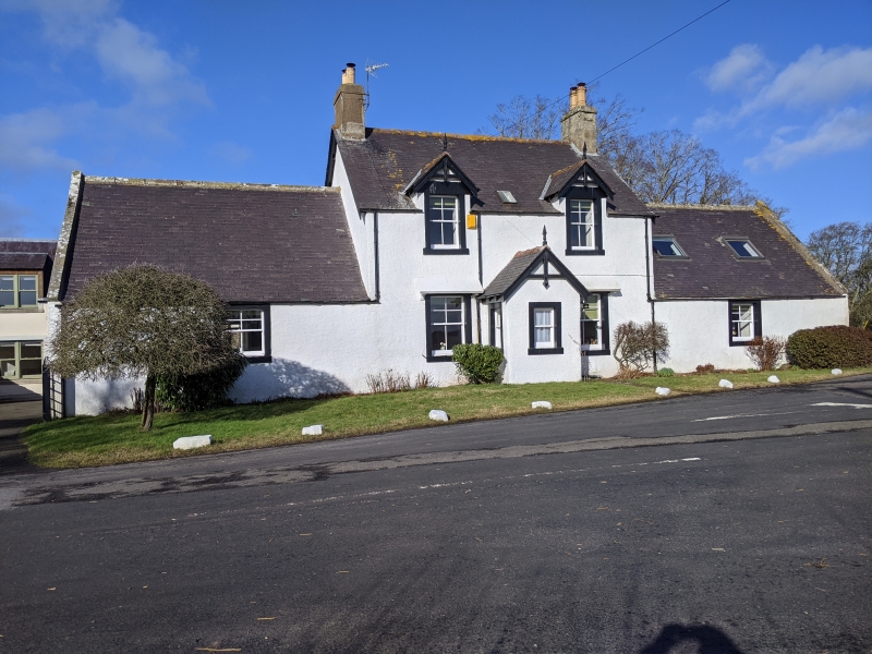
Earlier 19th century (possibly incorporating earlier fabric) with later alterations and additions. 2-storey 3-bay house with flanking single storey wings, forming symmetrical, picturesque group. Painted harl with painted ashlar margins.
SE ELEVATION: gabled porch to centre at ground with window to SE; door opening to NE return elevation. Window to each floor of flanking bays; windows at 1st floor breaking eaves, each with gabled dormerhead. Window to each single storey wing.
NW ELEVATION: single storey lean-to addition to rear of 3-bay group to centre with boarded door to centre flanked by windows. Modern glazed door in bay (wing) to outer left; window to bay (wing) to outer right.
Timber sash and case windows to SE, 4-pane upper sashes, 2-pane lower; variety of windows to remaining elevations. Purple graded slate roof with rendered stacks to gable apex to 2-storey section. 2-pane 19th century roof light to centre of NW. Modern rooflights to NE wing to SE and NW. Simple bargeboarding to gableheads and porch gable with timber finial to porch. Ashlar coped skews to wings.
INTERIOR: not seen, 1996.
According to the New Statistical Account: "There is a mineral well in this parish called the Dunse Spa. It is situated in a valley which lies nearly a mile on the south side of Dunse, on the estate of Nisbet. This well was discovered accidentally in 1747. It was a place of very general resort for a considerable time; but has long ceased to be so [in November 1834]. A very full account of the composition and virtues of this water has been given by Dr Francis Home, in a treatise published in Edinburgh, 1751. The well, however, is now entirely out of repute". This building stands in front of where the spa was, terminating the straight road which runs from Nisbet Hill (to W of Nisbet House). There is an outbuilding positioned to W.
External links are from the relevant listing authority and, where applicable, Wikidata. Wikidata IDs may be related buildings as well as this specific building. If you want to add or update a link, you will need to do so by editing the Wikidata entry.


Other nearby listed buildings
