Approximate Location Map
Large Map »
Latitude: 55.8164 / 55°48'59"N
Longitude: -3.0999 / 3°5'59"W
OS Eastings: 331175
OS Northings: 658676
OS Grid: NT311586
Mapcode National: GBR 61S5.PT
Mapcode Global: WH6TF.C23D
Plus Code: 9C7RRW82+H2
Entry Name: Braidwood
Listing Name: Braidwood Farm Including Gates, Gatepiers and Boundary Walls
Listing Date: 18 November 1998
Category: B
Source: Historic Scotland
Source ID: 392820
Historic Scotland Designation Reference: LB45808
Building Class: Cultural
ID on this website: 200392820
Location: Temple
County: Midlothian
Electoral Ward: Midlothian South
Parish: Temple
Traditional County: Midlothian
Tagged with: Building
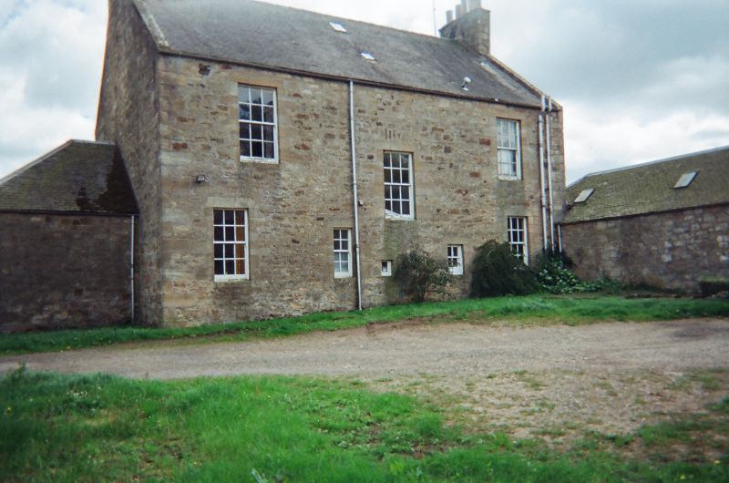
Earlier 19th century. 2 storey and attic, 3 bay, rectangular plan farmhouse with single storey, single bay wings with piended roofs. Tooled coursed sandstone with polished dressings to SE, rubble to remainder. Base course, eaves course. Raised margins to SE elevation; long and short dressings to remainder; long and short rusticated quoins to SE, droved quoins to remainder.
SE (PRINCIPAL) ELEVATION: near symmetrical; architraved doorway to centre of ground floor; recessed panelled timber door with decorative multi pane decorative fanlight. Later 19th century canted window in bay to right; stugged sandstone with chamfered reveals; window in bay to left. Regular fenestration to 1st floor. Piended slated dormer windows to left and right bays of attic. Single window to centre of each flanking wing.
NE ELEVATION: asymmetrical; wing off centre to left of ground. Window to left of 1st floor.
NW ELEVATION: asymmetrical; roughly 3 bay. Stair window to centre with relieving arch; small single pane window below; flanked by 4 pane window to right and 8 pane window to left of ground floor; windows to outer left and right bay of ground. Windows to left and right bays of 1st floor. Recessed wing to outer left. Wing to outer right extended; opening to right and sliding boarded timber door with diamond glazed panel.
SW ELEVATION: asymmetrical; wing off centre to right of ground floor; replacement window to centre. Extension to left with timber door.
Predominantly 4 pane and 12 pane timber sash and case windows. Grey slate roof with lead ridge. Stone skews. Coped tooled sandstone gablehead stacks with circular cans. Cast iron rainwater goods.
INTERIOR: not seen 1998.
GATES, GATEPIERS AND BOUNDARY WALLS: tooled, coursed sandstone gatepiers to NE, coped with spherical ball finials; decorative cast iron gate. Coursed sandstone wall with flat coping flanks gatepiers. Rubble wall with semicircular coping extends to SE.
A good example of a traditional farmhouse, symmetrically arranged with classical details. The bay window is a later addition.
External links are from the relevant listing authority and, where applicable, Wikidata. Wikidata IDs may be related buildings as well as this specific building. If you want to add or update a link, you will need to do so by editing the Wikidata entry.


Other nearby listed buildings
