Approximate Location Map
Large Map »
Latitude: 55.6195 / 55°37'10"N
Longitude: -3.0622 / 3°3'43"W
OS Eastings: 333201
OS Northings: 636726
OS Grid: NT332367
Mapcode National: GBR 731G.VD
Mapcode Global: WH6VD.X0ZT
Plus Code: 9C7RJW9Q+R4
Entry Name: 13A High Street
Listing Name: 13A and 15 High Street
Listing Date: 21 May 2008
Category: C
Source: Historic Scotland
Source ID: 399900
Historic Scotland Designation Reference: LB51078
Building Class: Cultural
ID on this website: 200399900
Location: Innerleithen
County: Scottish Borders
Town: Innerleithen
Electoral Ward: Tweeddale East
Traditional County: Peeblesshire
Tagged with: Architectural structure
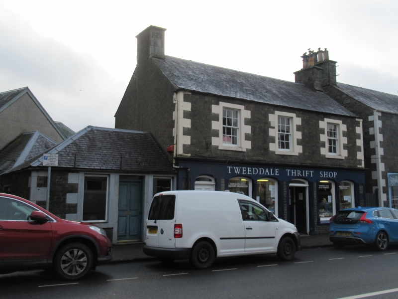
Early 19th century with late 19th century alterations. 2-storey with attic, 3-bay, T-plan shop and house with later 19th century 6-bay colonnaded shop front façade to ground floor incorporating door to accommodation above. Coursed snecked whinstone to principal elevation, random rubble and render to rear and gables. Painted droved sandstone quoins and tabs to raised window margins. Shallow arches with stop chamfered arrises and sloping cills to ground floor. Single-storey gabled wing to rear forming T-plan. Canted dormer with slated cheeks to rear elevation.
12-pane glazing in timber sash and case windows. Grey slate roof, ashlar gable stacks with plain clay cans. Cast-iron rainwater goods.
INTERIOR: plain vertical boarding to shop interior.
13A and 15 High Street are a well-preserved example of an early 19th century townhouse built with an integrated shop and with a fine later 19th century colonnaded shop front. The building makes a strong contribution to the streetscape of the High Street and forms a good pairing with the adjacent Robert Smail's Printworks (see separate listing).
A photograph in Robb and Stevenson shows the original form of the building with 2 entrance doors and a simple shop front with small window to the street the same size as the windows of the first floor. The later highly glazed shopfront to ground demonstrates the development of the High Street's commercial premises in the late 19th century. It is a fine example of a shop front of this type in the town.
The building is marked on the 1st Edition map as the Glasgow Bank.
External links are from the relevant listing authority and, where applicable, Wikidata. Wikidata IDs may be related buildings as well as this specific building. If you want to add or update a link, you will need to do so by editing the Wikidata entry.


Other nearby listed buildings
