Approximate Location Map
Large Map »
Latitude: 53.1687 / 53°10'7"N
Longitude: -3.141 / 3°8'27"W
OS Eastings: 323821
OS Northings: 364113
OS Grid: SJ238641
Mapcode National: GBR 6Z.4CJF
Mapcode Global: WH775.QMH6
Plus Code: 9C5R5V95+FH
Entry Name: Church Hall
Listing Date: 30 March 1987
Last Amended: 30 March 1987
Grade: II
Source: Cadw
Source ID: 388
Building Class: Religious, Ritual and Funerary
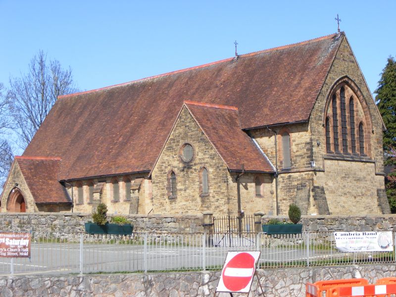
Also known as: St John the Evangelist's Church, Mold
ID on this website: 300000388
Location: In a prominent position opposite the modern police station.
County: Flintshire
Community: Mold (Yr Wyddgrug)
Community: Mold
Built-Up Area: Mold
Traditional County: Flintshire
Tagged with: Church building Church hall
1878-9 by John Douglas of Chester. Built as St John's Welsh Church but now sub-divided as a church hall. Arts and Crafts Gothic.
Broad 5 bay aisle-less nave, 3 bay chancel. Low Ss transept with basement forms base of intended tower with projecting stair turret.
Random squared rubble with red Helsby dressings, steep red tile roofs with toothed ridge. Plain verges, exposed raftes at eaves. 2 iron crucifixes to ridge.
Raked buttresses, angled to chancel. Two centred arch with hoodmould to porch, quatrefoil side windows.
3 blocked stepped lancets to W end. Paired lancets to nave, narrower lancets to chancel, S transept and "tower". Oculus in S transept gable. 5 stepped lancets under single two centred arch with hoodmould to east end. String course steps up to sill.
Interior of stock brick with plain brick hoods to windows. Suspended ceiling inserted.
External links are from the relevant listing authority and, where applicable, Wikidata. Wikidata IDs may be related buildings as well as this specific building. If you want to add or update a link, you will need to do so by editing the Wikidata entry.


Other nearby listed buildings
