History in Structure

Former Chapel at Lluesty Hospital

A Grade II Listed Building in Holywell, Flintshire

More Photos »
Approximate Location Map
Large Map »

Coordinates

Latitude: 53.2663 / 53°15'58"N

Longitude: -3.2168 / 3°13'0"W

OS Eastings: 318937

OS Northings: 375054

OS Grid: SJ189750

Mapcode National: GBR 5ZZN.CV

Mapcode Global: WH76R.K5DB

Plus Code: 9C5R7Q8M+G7

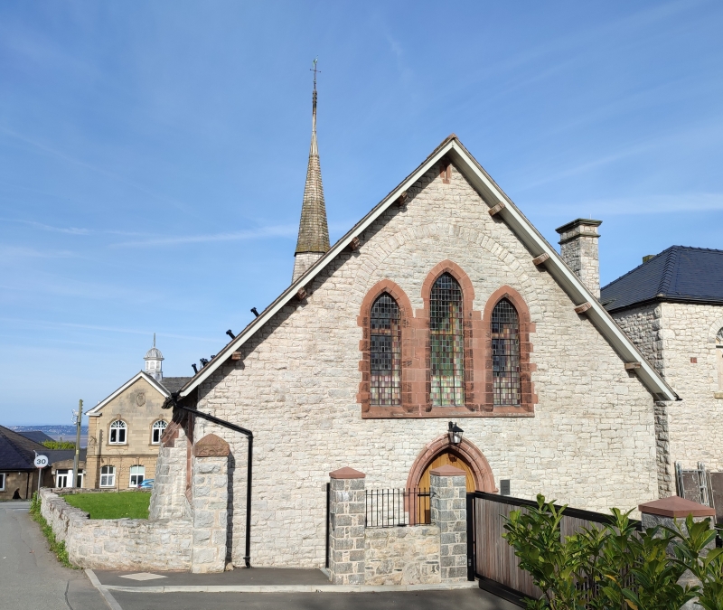
Entry Name: Former Chapel at Lluesty Hospital

Listing Date: 19 August 1991

Last Amended: 19 August 1991

Grade: II

Source: Cadw

Source ID: 455

Building Class: Health and Welfare

Also known as: Chapel at Lluesty Hospital

ID on this website: 300000455

Location: Immediately to N of the main hospital building with E gable end facing the road.

County: Flintshire

Community: Holywell (Treffynnon)

Community: Holywell

Built-Up Area: Holywell

Traditional County: Flintshire

Tagged with: Chapel Gothic Revival

Find accommodation in
Holywell

History

Built 1883-4 as the hospital chapel by John Douglas, architect of Chester.
Modern conversion to medical usage.

Exterior

Early English Gothic. Rubble masonry with red sandstone dressings; slate roof, overhanging eaves and octagonal shingled fleche; later brick chimney stacks. Stepped 3-light end windows; to W, with relieving arch and set over the main entrance which has label and boarded doors; to E, with giant arch label, flanking buttresses and small outer lancets. Shallow pointed arch windows to 5-bay sides with raking buttresses.

Interior

Altered interior.

Reasons for Listing

Group value with Lluesty Hospital.

External Links

External links are from the relevant listing authority and, where applicable, Wikidata. Wikidata IDs may be related buildings as well as this specific building. If you want to add or update a link, you will need to do so by editing the Wikidata entry.

Recommended Books

Other nearby listed buildings

  • II Lluesty Hospital
    High up near the S end of the Community Council area; approximately 1km from the town centre.
  • II 21
    At a splayed angle to the road midway up the hill. Red brick forecourt wall with Gothic inspired caps to the gate piers. Formerly Ysgol-y-Fron.
  • II 9
    Midway along the street, at a splayed angle. Rubble boundary wall with brick gate piers.
  • II Territorial Army Drill Hall
    Midway along the street, at a splayed angle. Rubble boundary wall with brick gate piers.
  • II Holywell County Court
    Detached forward to the street.
  • II Masonic Hall
    Long building at right angles to the road and to left of Nos 10 and 12; set back behind walled forecourt.
  • II Old Bank House
    Set back behind raised forecourt with railings curving around at ends, at right running back towards screen wall linking No 10 and the neighbouring chapel; round arched entrance to courtyard of Maes-y
  • II Maes-Y-Dre
    Set back behind raised forecourt with railings curving around at ends, at right running back towards screen wall linking No 10 and the neighbouring chapel; round arched entrance to courtyard of Maes-y

BritishListedBuildings.co.uk is an independent online resource and is not associated with any government department. All government data published here is used under licence. Please do not contact BritishListedBuildings.co.uk for any queries related to any individual listed building, planning permission related to listed buildings or the listing process itself.

British Listed Buildings is a Good Stuff website.