History in Structure

Pont-y-Llan

A Grade II Listed Building in Nantglyn, Denbighshire

More Photos »
Approximate Location Map
Large Map »

Coordinates

Latitude: 53.1472 / 53°8'50"N

Longitude: -3.4899 / 3°29'23"W

OS Eastings: 300447

OS Northings: 362158

OS Grid: SJ004621

Mapcode National: GBR 6J.5QQT

Mapcode Global: WH662.C5C3

Plus Code: 9C5R4GW6+V2

Entry Name: Pont-y-Llan

Listing Date: 19 July 1966

Last Amended: 15 December 1998

Grade: II

Source: Cadw

Source ID: 813

Building Class: Transport

ID on this website: 300000813

Location: Spanning the Afon Ystrad in the centre of the village.

County: Denbighshire

Town: Denbigh

Community: Nantglyn

Community: Nantglyn

Traditional County: Denbighshire

Tagged with: Architectural structure

Find accommodation in
Nantglyn

History

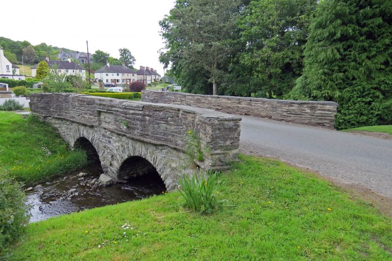
Road bridge built in 1831, probably replacing a ford crossing.

Exterior

Small 2-span road bridge, of rubble construction with small segmental arches and long, rough-dressed voussoirs. Rubble parapet with plain string course below, returned onto simple terminating piers at the splayed approaches; largely-restored slate copings. On the upstream side the parapet has a blind rectangular recess to its centre.

Reasons for Listing

Listed for its special interest as a vernacular road bridge retaining good character in this village context.

External Links

External links are from the relevant listing authority and, where applicable, Wikidata. Wikidata IDs may be related buildings as well as this specific building. If you want to add or update a link, you will need to do so by editing the Wikidata entry.

Recommended Books

Other nearby listed buildings

  • II Parish Church of St James
    Located on a raised, near-circular site in the centre of the village; its churchyard contains two ancient yew trees.
  • II Telephone Call-box
    Prominently-located in the village centre, adjoining Cae Llwyd and the Post Office; sited on W side of minor road running uphill from Pont y Llan to N.
  • II Glasmor
    Located prominently on the corner, at the crossroads at the S end of the village street.
  • II Barn Range to the W of Glasmor
    Prominently located at the crossroads at the southern end of the village, opposite Glasmor.
  • II Agricultural Range immediately S of Glasmor
    Prominently located at the crossroads at the southern end of the village, opposite Glasmor.
  • II Pont Newydd
    Located some 200m NE of Nantglyn village spanning the Afon Ystrad and carrying the old Denbigh to Nantglyn road immediately E of its modern successor.
  • II The Rectory
    Located approximately 1km NE of Nantglyn village, raised up on a bank to the E of the road from Denbigh to Nantglyn; immediately E of the old Pont Newydd. The house is set into a hillslope.
  • II Waen Presbyterian Chapel and School Hall
    Set back from the road behind rendered rubble forecourt walls with simple surmounting railings; sited into the slope of a hill.

BritishListedBuildings.co.uk is an independent online resource and is not associated with any government department. All government data published here is used under licence. Please do not contact BritishListedBuildings.co.uk for any queries related to any individual listed building, planning permission related to listed buildings or the listing process itself.

British Listed Buildings is a Good Stuff website.