Approximate Location Map
Large Map »
Latitude: 53.1088 / 53°6'31"N
Longitude: -3.3289 / 3°19'44"W
OS Eastings: 311134
OS Northings: 357668
OS Grid: SJ111576
Mapcode National: GBR 6R.81W8
Mapcode Global: WH77G.T4Z2
Plus Code: 9C5R4M5C+GC
Entry Name: The Old Alms Cottages
Listing Date: 24 October 1950
Last Amended: 12 July 2006
Grade: II
Source: Cadw
Source ID: 824
Building Class: Domestic
ID on this website: 300000824
Location: In a low-lying position, set back from the road, within a bend of the B5101 road.
County: Denbighshire
Town: Ruthin
Community: Ruthin (Rhuthun)
Community: Ruthin
Locality: Llanfwrog
Traditional County: Denbighshire
Tagged with: Cottage
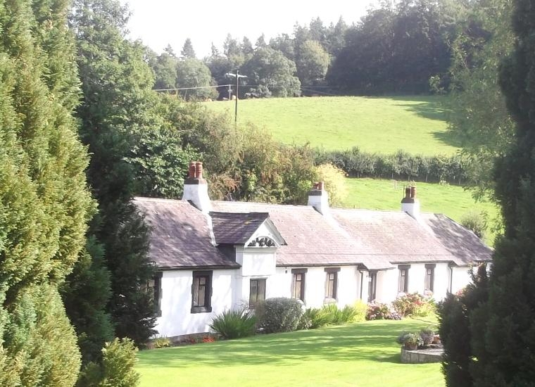
Almshouses rebuilt and dated 1708. A long range of 10 single-storey cottages with 5 shared entrances and 5 chimney stacks. Modernised and converted into 2 properties in the mid-late C20. Now one property.
Single-storey range with half-hipped roof to N end. Rendered over stone under a slate roof, 4 rendered chimney stacks with offsets. Large mid-late C20 wooden windows with diamond glazing, casements and top-hung lights. Small gable to centre of W side, the original main entrance. It has a raised segmental pediment enclosing carved foliage and a date. Further entrances flanking, shallow catslide lean-to porches, the doors replaced by windows. Large window to N gable end. Rear not seen.
Interior not seen.
Listed as a rare example of village almshouses, the early C18 date unusual for such a building type; much of the original detail has been lost, but the range retains its form and character.
External links are from the relevant listing authority and, where applicable, Wikidata. Wikidata IDs may be related buildings as well as this specific building. If you want to add or update a link, you will need to do so by editing the Wikidata entry.


Other nearby listed buildings
