Approximate Location Map
Large Map »
Latitude: 53.1098 / 53°6'35"N
Longitude: -3.3273 / 3°19'38"W
OS Eastings: 311246
OS Northings: 357777
OS Grid: SJ112577
Mapcode National: GBR 6R.8287
Mapcode Global: WH77G.V3R9
Plus Code: 9C5R4M5F+W3
Entry Name: Brynffynon
Listing Date: 16 May 1978
Last Amended: 12 July 2006
Grade: II
Source: Cadw
Source ID: 894
Building Class: Domestic
ID on this website: 300000894
Location: Located at the bottom of a hill, approx 110m W of the Church of St Mwrog, opposite a fork in the road.
County: Denbighshire
Town: Ruthin
Community: Ruthin (Rhuthun)
Community: Ruthin
Locality: Llanfwrog
Built-Up Area: Ruthin
Traditional County: Denbighshire
Tagged with: Cottage
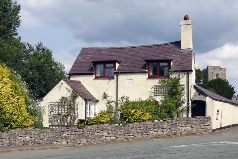
Dated 1746. Late C20 alterations to openings.
Two-window cottage of one-and-a-half storeys; roughcast under a slate roof with rendered end stack to R. Modern gabled porch to far L, with entrance to R-hand return containing a half-glazed boarded door with side-lights. Late C20 wooden windows with casements and top-hung lights; front has large 3-light window to ground floor offset to R of centre; 2 flat-roofed half-dormers with 2-light windows. To the centre, towards the top of the wall, is a rectangular stone tablet with an elegant rustic inscription 'HIE / Brynfynnon / 1746. To rear, ground floor has small 2-light casement to L and tall single light to R. Single-storey lean-to against S gable end, its S wall at an angle, following the boundary of the road. It has a boarded door under a segmental head to W front; a letter box is inserted into the W wall. Lean-to against N gable end, probably of 2 phases; front not seen, small 2-light casement to rear.
Interior not seen.
Listed for its special interest as a small dated C18 cottage in a village setting, retaining its plan-form and character, notwithstanding alterations to openings.
External links are from the relevant listing authority and, where applicable, Wikidata. Wikidata IDs may be related buildings as well as this specific building. If you want to add or update a link, you will need to do so by editing the Wikidata entry.


Other nearby listed buildings
