History in Structure

Fron Deg

A Grade II Listed Building in Llangollen, Denbighshire

More Photos »
Approximate Location Map
Large Map »

Coordinates

Latitude: 52.9788 / 52°58'43"N

Longitude: -3.1785 / 3°10'42"W

OS Eastings: 320968

OS Northings: 343034

OS Grid: SJ209430

Mapcode National: GBR 6Y.J8F2

Mapcode Global: WH784.4DP7

Plus Code: 9C4RXRHC+GJ

Entry Name: Fron Deg

Listing Date: 22 December 1989

Last Amended: 22 December 1989

Grade: II

Source: Cadw

Source ID: 1243

Building Class: Domestic

Also known as: Fron Deg,Abbey Road,A542 (E.Side) Dinbren

ID on this website: 300001243

Location: Approximately 1km N of the town centre. Above the road close to the junction with Tower Road and the modern road bridge over the Llangollen Canal.

County: Denbighshire

Community: Llangollen

Community: Llangollen

Locality: Dinbren

Built-Up Area: Llangollen

Traditional County: Denbighshire

Tagged with: Architectural structure

Find accommodation in
Llangollen

Exterior

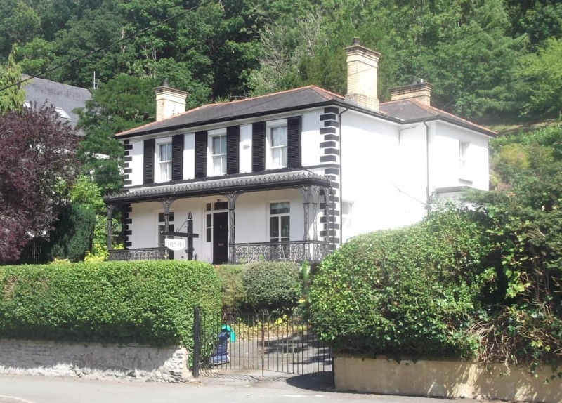
Mid C19 2-storey villa with scribed render elevations; hipped slate roofs with wide boarded eaves and stock brick chimney stacks. Symmetrical 3-window front with rusticated quoins and 1st floor cill band. 4-pane sashes with shutters to 1st floor, French windows below. Central 4-panel door entrance with side and over-lights. Good cast-iron Coalbrookdale verandah with anthemion cresting, traceried spandrels and highly ornate oval-panelled balastrade to the terrace.
Advanced bay to S over side porch.

Reasons for Listing

Included because of the special intrest of the ironwork.

External Links

External links are from the relevant listing authority and, where applicable, Wikidata. Wikidata IDs may be related buildings as well as this specific building. If you want to add or update a link, you will need to do so by editing the Wikidata entry.

Recommended Books

Other nearby listed buildings

  • II Sycamore
    Approximately 1km NW of the town centre. Below the road with rear elevation overlooking the railway. On steeply sloping ground close to modern road bridge over the Llangollen Canal.
  • II The Tower
    Above the road on a bend in the hill. A prominent building when looking E from The Geraint. Said to have been a watchtower for Castle Dinas Bran; also sometime school.
  • II Penddol
    Below the E bank of the Llangollen Canal and to N of the Eisteddfod ground. Reached off Abbey Road and over Canal bridge No 46.
  • II Canal Bridge (no.46 at Penddol)
    Immediately to S Penddol and N of the Eisteddfod ground. Spanning the Llangollen Canal and reached off Abbey Road.
  • II Dinbren Hall
    Prominently sited on the edge of a steep slope to W of Castell Dinas Bran. The house faces S and is reached by a drive from the by-road which runs E from Pentrefellin and N from the town centre.
  • II Cilmedw Cottages
    Approximately 1km NW of the town centre midway between The Duke and The Geraint. At a splayed angle to the road at the point where the old lane following the W bank of the River Dee meets the later H
  • II Colmedw Cottages
    Approximately 1km NW of the town centre midway between The Duke and The Geraint. At a splayed angle to the road at the point where the old lane following the W bank of the River Dee meets the later H
  • II Henllys
    High above the modern A5, to NW of the town reached from a lane that was in the early C19 the main Holyhead Road. On levelled site with broad views to NE.

BritishListedBuildings.co.uk is an independent online resource and is not associated with any government department. All government data published here is used under licence. Please do not contact BritishListedBuildings.co.uk for any queries related to any individual listed building, planning permission related to listed buildings or the listing process itself.

British Listed Buildings is a Good Stuff website.