Approximate Location Map
Large Map »
Latitude: 52.8574 / 52°51'26"N
Longitude: -4.052 / 4°3'7"W
OS Eastings: 261938
OS Northings: 330856
OS Grid: SH619308
Mapcode National: GBR 5T.S05N
Mapcode Global: WH560.QFPR
Plus Code: 9C4QVW4X+X6
Entry Name: Gerddi Bluog
Listing Date: 28 April 1952
Last Amended: 23 May 2003
Grade: II
Source: Cadw
Source ID: 4772
Building Class: Recreational
ID on this website: 300004772
Location: A country road that branches E off Fonllef Hir and leads to the Cwm Bychan road; c4km NE of Llanfair it passes through the farmyard at Gerddi Bluog. The house is sited to E of the road.
County: Gwynedd
Community: Llanfair
Community: Llanfair
Traditional County: Merionethshire
The original farmhouse is probably late C17, and dated by a re-set stone which forms the lintel of a doorway and bears the date and the initials: MP 1667 (for Morgan Prys, son of Edmund Prys (1544-1623), poet, vicar of Maentwrog and Archdeacon of Merioneth). The house was long-thought to have been the birthplace of Archdeacon Prys translator of the psalms into Welsh; It was in pursuit of this association that the house was visited by Owen M Edwards, who described the traditional Welsh interior in his book ''Cartrefi Cymru'', 1896. The farmhouse originally had a large advanced stack at the W gable which was later extended to either side to form flanking rooms or ''cubby holes'' and in C19 an additional storeyed wing was added to the S.
In the mid C19 the house formed the centre of an extensive farmstead of over 383 acres, owned by Jane Roberts and occupied by Griffith Jones.
In the late 1960s the house was transformed to the designs of Clough Williams Ellis who was commissioned to enlarge and transform Gerddi Bluog by the then owner. The changes made were controversial and involved gutting the interior of the oldest part of the house of all timberwork including original panelling and a 4-poster bed described by Edwards. He inserted large mullioned windows in the S and E walls of the remaining fabric of the old house, demolished the ''tyddyn traean'' to the N and replaced it with a large room, open to the roof, built to an L-shaped plan.
The owner, upon completion of the transformation, considered the house to be unsuitable for occupation. It was however, considered suitable for use as a hostel and was purchased by the Youth Hostels Association in 1976 who were encouraged by a proposed plan for a path to cross the Snowdonia National Park from N to S, and the large airy rooms were converted into dormitories. Unfortunately the planned footpath was never made and the property was sold to a private educational trust in 1982.
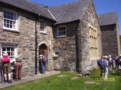
Large building comprising the fabric of a late C17 farmhouse which was extended to it''s rear (S) by a 2-window C19 wing to form a T-shaped plan; altered and further extended by an L-shaped block to N in mid C20.
Built of coursed rubble masonry with large stones as quoins; the S gable of the C19 wing is rendered. The openings of the C19 wing (and some windows in the C17 part) have stone lintels and the windows have slate sills. The C20 addition has large mullioned windows, thought by the owner to be of cast cement rather than stone. Slate roof with tiled ridge and slate copings; gable stacks at W end of C16 part and S gable of C19 wing.
The building comprises 2 main builds, of different character, with the principal (more formal) part to N having advanced wings flanking a central block, which in turn has a central entrance flanked by large windows of 9-small paned lights; the main doorway has a Tudor arched head of raking stones. The southernmost of the advanced wings is the altered C16 farmhouse which is abutted by the C19 wing. This part has a more vernacular character, the entrance is offset to the R (N) end of the C19 wing and has the re-set stone lintel which bears the date and initials: MP 1667; windows are horned sashes of 12 and 16 panes.
The interior was modernised when the building was extended and altered in the mid C20. Retains the original central ''front'' doorway to the late C17 farmhouse, raking stones set in the local style as the head.
Listed for its historical association with the Prys family which has given the house a significant place in Welsh culture; Despite extensive alteration by Clough Williams-Ellis, the building retains some sub-medieval character and is at the heart of a small agricultural estate.
External links are from the relevant listing authority and, where applicable, Wikidata. Wikidata IDs may be related buildings as well as this specific building. If you want to add or update a link, you will need to do so by editing the Wikidata entry.


Other nearby listed buildings
