Approximate Location Map
Large Map »
Latitude: 52.1706 / 52°10'14"N
Longitude: -3.1716 / 3°10'17"W
OS Eastings: 319969
OS Northings: 253132
OS Grid: SO199531
Mapcode National: GBR YZ.5FWF
Mapcode Global: VH69X.ZP4V
Plus Code: 9C4R5RCH+79
Entry Name: Church of St David
Listing Date: 21 September 1962
Last Amended: 31 January 1995
Grade: II*
Source: Cadw
Source ID: 8773
Building Class: Religious, Ritual and Funerary
ID on this website: 300008773
Location: Elevated and largely isolated setting. The church is set into the hill slope above the by-road from Gladestry to Glascwm.
County: Powys
Community: Gladestry (Llanfair Llythynwg)
Community: Gladestry
Locality: Colva
Traditional County: Radnorshire
Tagged with: Church building
C13 or earlier, partial restoration in C19 and 1980''s.
Low nave and chancel under single roof line. C15 wide south porch, C18 timber bellcote with pyramid roof. Coursed rubble including the west end of the bellcote, shingle roof. Two early small openings in north wall, one with arched head, paired lancets to south and east of chancel, square-headed diamond paned window to north nave wall, C18 paired round-headed two-light window to south nave wall. Substantial roof trusses to porch, the outer two arch-braced with soffit chamfers, the centre one a collar truss with cusped apex braces, single row of cusped wind-braces. Stone benches. C15 moulded doorways and boarded door with remnants of the original hinges.
Sloping ground to churchyard with few headstones, some chest tombs.
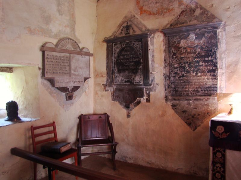
Undivided nave/sanctuary. Arch-braced trusses with alternating tie beams and stub ties, boarded underside. High rubble base to tower partition framing. Some dado panelling. c.1200 font - plain round bowl on cylindrical base, tiled floor, C17 communion table. Modern furnishing. Plastered walls with traces of wall paintings uncovered during restoration of 1980''s and now largely illegible. RCAHM survey recorded them whilst fresh, mainly C18 texts but skull and cross bones survive on north wall. On west wall painted Royal Arms board with lion and unicorn signed J Cartwright de Abaredew pinxit 1733, relettered above - Thos Davies Churchwarden 1838 and Royal cipher altered to VR. C18/C19 wall tablets at east end. Tower framing C18, two bells dated 1707 and 1740.
Though modest in scale, Colva Church retains considerable unspoilt character from medieval and later periods.
External links are from the relevant listing authority and, where applicable, Wikidata. Wikidata IDs may be related buildings as well as this specific building. If you want to add or update a link, you will need to do so by editing the Wikidata entry.


Other nearby listed buildings
