Approximate Location Map
Large Map »
Latitude: 51.4074 / 51°24'26"N
Longitude: -3.4884 / 3°29'18"W
OS Eastings: 296572
OS Northings: 168648
OS Grid: SS965686
Mapcode National: GBR HJ.QF8R
Mapcode Global: VH5HZ.HW5G
Plus Code: 9C3RCG46+XJ
Entry Name: The Old Police Station
Listing Date: 10 September 1982
Last Amended: 16 December 2004
Grade: II
Source: Cadw
Source ID: 13273
Building Class: Civil
ID on this website: 300013273
Location: About 80m south-west of the Church of St. Illtud.
County: Vale of Glamorgan
Town: Cowbridge / Y Bont-Faen
Community: Llantwit Major (Llanilltud Fawr)
Community: Llantwit Major
Built-Up Area: Llantwit Major
Traditional County: Glamorgan
Tagged with: Police station
c1850, it is not shown on the 1840 Tithe map. This building remained the Police Station until the present Llantwit Major one was opened in Wesley Street in 1928.
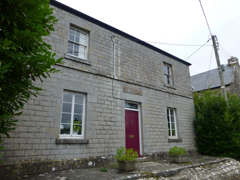
Local limestone walls. Welsh slate hipped roof with stone flanking stacks. Two storeys.
Front elevation of two window bays and centre doorway and faced with coursed dressed stone of near ashlar quality. The openings with stone lintels; string course; stone plinth. On the ground floor, a tall 2-light casement with 4 4 panes each side of central 4-panel door with overlight; a sash window with 6 over 6 panes to each side on first floor.
Contemporary centre rear projection with hipped roof, cement rendered cladding which is now removed leaving more roughly finished stonework than on the front. Two sash windows on first floor with cambered heads.
To the north-west in Church Lane there is an adjoining lean-to single storey wing with stone walls, stone stack and slate roof.
Internal shutters to ground floor windows of front elevation. Interior otherwise not seen at resurvey.
Included as an unaltered small mid C19 Police Station and for its important group value with the medieval gatehouse, the Chantry House or Cottage and the Parish Church of St Illtud in the view of Hillhead from the east.
External links are from the relevant listing authority and, where applicable, Wikidata. Wikidata IDs may be related buildings as well as this specific building. If you want to add or update a link, you will need to do so by editing the Wikidata entry.


Other nearby listed buildings
