Approximate Location Map
Large Map »
Latitude: 52.9865 / 52°59'11"N
Longitude: -3.3706 / 3°22'13"W
OS Eastings: 308089
OS Northings: 344124
OS Grid: SJ080441
Mapcode National: GBR 6P.HXD7
Mapcode Global: WH781.6678
Plus Code: 9C4RXJPH+JQ
Entry Name: Farmbuildings at Trewyn Fawr
Listing Date: 1 February 1995
Last Amended: 1 February 1995
Grade: II
Source: Cadw
Source ID: 15538
Building Class: Agriculture and Subsistence
ID on this website: 300015538
Location: SE of the farmhouse, below the road close to the junction with the lane leading to Corwen.
County: Denbighshire
Community: Corwen
Community: Corwen
Traditional County: Merionethshire
Tagged with: Agricultural structure
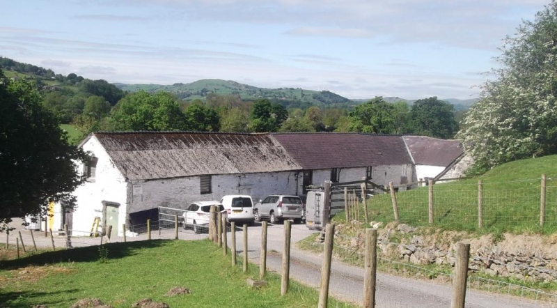
Probably mid-late C18.
An L-shaped range of buildings comprising shippons, stables etc. Roughly coursed whitewashed rubble with slate and corrugated tin roofs. Stable in the shorter W range, a single storeyed building with 2 doorways, each with a window alongside, all openings with tooled slate lintels. A separate building adjoins to the right, with 2 doorways, one with rough timber lintel. Shippon etc. in the long S range: One low original doorway towards centre of right hand range in N facing elevation, and inserted opening towards corner with stable, and 2 upper windows and a small loft entry below eaves above. A further loft doorway up steps towards the left of this range. Paired wide segmentally arched openings to cart shed in the lower (S) elevation. Left hand section has added brick lean-to against N wall, doorways in gable elevation, and central doorway in rear (S) elevation, flanked by vents and two small square windows.
Trewyn Fawr represents a good example of a C18 farmstead, in which the farm buildings survive substantially intact and form a group with the farmhouse.
External links are from the relevant listing authority and, where applicable, Wikidata. Wikidata IDs may be related buildings as well as this specific building. If you want to add or update a link, you will need to do so by editing the Wikidata entry.


Other nearby listed buildings
