Approximate Location Map
Large Map »
Latitude: 52.0439 / 52°2'38"N
Longitude: -3.1948 / 3°11'41"W
OS Eastings: 318153
OS Northings: 239064
OS Grid: SO181390
Mapcode National: GBR YY.FG5H
Mapcode Global: VH6BH.KWXJ
Plus Code: 9C4R2RV4+H3
Entry Name: Railway Bridge at Treble Hill
Listing Date: 15 December 1995
Last Amended: 15 December 1995
Grade: II
Source: Cadw
Source ID: 17067
Building Class: Transport
ID on this website: 300017067
Location: Located on the minor road from Treble Hill Glasbury to Felindre, approximately 100m from the junction with the A438 SW of the Glasbury Bridge.
County: Powys
Community: Gwernyfed
Community: Gwernyfed
Locality: Treble Hill
Traditional County: Brecknockshire
Tagged with: Railway bridge
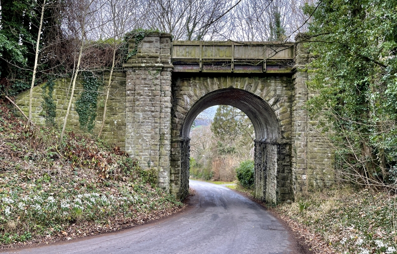
The Brecon to Eardisley tramroad was bought by the Hereford, Hay and Brecon Railway Co. (HHB) on the 6th June 1862. It improved the line and radii of curves over the next few years, including building the Glasbury Cutting. The railway was amalgamated with the Brecon and Merthyr Railway in 1865, and the whole line was leased to the Midland Railway Company in 1874, then becoming known as the Mid-Wales Railway. The line was closed in 1963.
Railway bridge of c1864-5 for the Hereford, Hay and Brecon Branch of the Mid-Wales Railway. Rock faced ashlar sandstone, the corners and features margin-draughted, and the vault turned in brick. Tall semi-circular arch rising from a projecting string course, the voussoirs and keystones pronounced, and flanked by piers having a pilaster standing forward of the sharply curved flank retaining walls of the embankment. Limestone cornice and caps to the pilasters. The bridge is in its original condition on the NW side, the parapet slightly extended in iron on the SE side.
Included as a noble design and a rare surviving largely unaltered example of a railway structure on the Midland railway, later the Hereford, Hay and Brecon Railway.
External links are from the relevant listing authority and, where applicable, Wikidata. Wikidata IDs may be related buildings as well as this specific building. If you want to add or update a link, you will need to do so by editing the Wikidata entry.


Other nearby listed buildings
