Approximate Location Map
Large Map »
Latitude: 52.0459 / 52°2'45"N
Longitude: -3.2742 / 3°16'27"W
OS Eastings: 312710
OS Northings: 239383
OS Grid: SO127393
Mapcode National: GBR YV.F6GN
Mapcode Global: VH6BG.6TFY
Plus Code: 9C4R2PWG+98
Entry Name: Boughrood Court
Listing Date: 18 January 1996
Last Amended: 18 January 1996
Grade: II*
Source: Cadw
Source ID: 17187
Building Class: Domestic
ID on this website: 300017187
Location: Located 100m to the NW of Boughrood church across a small tributary of the River Wye, within its own grounds, and with its farmyard, buildings and mill to the N.
County: Powys
Community: Glasbury (Y Clas-ar-wy)
Community: Glasbury
Locality: Boughrood
Traditional County: Radnorshire
Tagged with: Building
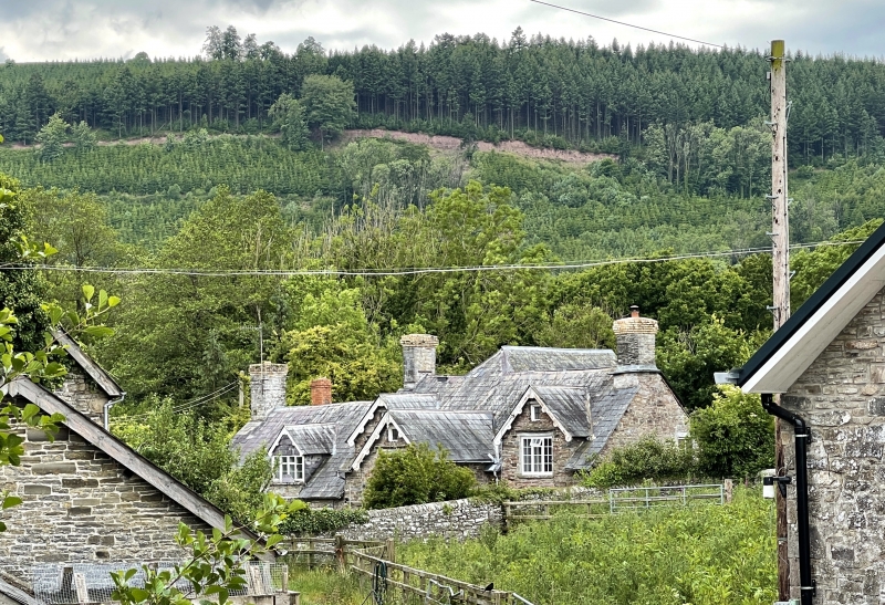
A large cruck-built farmhouse of the C16 or earlier, the N end of which was converted and raised to 2 storeys with attic in a high-quality early C17 scheme of remodelling.
Coursed rubble local stone, with slate roof. The Court occupies the 3 bays at the N end and the Cottage in the 2 bays at the S end with continuous later lean-to at rear, the former having a C17 gabled open stone porch with side benches, and an added 2-storey rear wing with a C17 stair occupying one third of the width. Porch outer opening is segmental headed, perhaps rebuilt. Inner door to house has an oak frame, with double ovolo and quirks moulding. Four plank counterboarded door, with ogee-moulded coverstrips, all fully studded, and having original ironmongery. Paned casement windows, mostly C19 and C20, but 6-pane sashes to ground floor, and gables raised over the bays either side of the porch, with the windows having flush timber lintels and drip mouldings, and small ovolo-moulded lights at attic level. C19 bargeboards with spaced roundels. The 2½ storey rear wing also has 2 windows to each floor, with oak lintels and drip course over.
The early building is constructed with crucks defining 4 bays, of which three couples remain, one opposite the entrance to the Court, one within the stack of the Cottage and one at the lower end. They have deep elbows and bareface half-dovetailed lap joints, the apex tenoned and notched for the ridge. Very large scantling purlins. End parlour has an axial beam and wall beams carrying floor, all with elongated ogee chamfer stops. Main hall has 4 similar longitudinal beams, also with elongated ogee stops, and a late C17-early C18 bolection-moulded chimneypiece, augmented with a later mantle shelf. Each room has a rear door into the stairwell, each having a shaped head set within the frame, (one head now removed to cellar). The oak stair is framed with moulded handrail on pierced and shaped splat balusters between square newels rising to moulded cagework terminals, the motif reflected in an applied board with a shaped terminal between the doors to the first floor rooms. The stair bears an added mark I.F. 1856, but this does not appear to represent a date for any major alteration. Small rooms or closets off the stairway have ovolo moulded oak lintels with ogee stops to the windows. Arch-headed door at head of stair leads to the roof space.
Listed Grade II* on account of the evidence of sub-medieval construction and for the unusually high quality of the C17 work retained internally.
External links are from the relevant listing authority and, where applicable, Wikidata. Wikidata IDs may be related buildings as well as this specific building. If you want to add or update a link, you will need to do so by editing the Wikidata entry.


Other nearby listed buildings
