Approximate Location Map
Large Map »
Latitude: 52.5479 / 52°32'52"N
Longitude: -3.1333 / 3°7'59"W
OS Eastings: 323247
OS Northings: 295058
OS Grid: SO232950
Mapcode National: GBR B0.DK8Q
Mapcode Global: VH686.M7X2
Plus Code: 9C4RGVX8+5M
Entry Name: Toll Cottage
Listing Date: 1 October 1996
Last Amended: 1 October 1996
Grade: II
Source: Cadw
Source ID: 17370
Building Class: Domestic
ID on this website: 300017370
Location: Located in the detached part of Churchstoke Community on the B4385 between Churchstoke and Montgomery. The cottage faces directly onto the road and has a small garden to the S.
County: Powys
Town: Montgomery
Community: Montgomery (Trefaldwyn)
Community: Montgomery
Locality: Weston Madoc
Traditional County: Montgomeryshire
Tagged with: Cottage
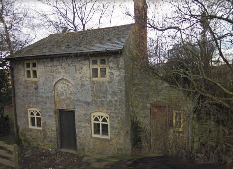
2 bay, 2 storey cottage. Rubble masonry under a tile roof with a red brick end stack. Central doorway, with plain, planked door in a simple doorcase. There is a recessed panel above with a brick arched head, which was probably used for displaying toll charges. 2 window range. 4-pane wooden casement windows rising to the eaves on the first floor. The ground storey windows are under segmental brick arched heads, and contain glazing bars forming lancet-shaped heads, lending a Gothic appearance. There is a brick lean-to to the N, possibly a toilet block, with a planked door and a 4-pane casement window. There are small windows in the S gable. The rear was not accessible.
No access to the interior at time of inspection (February 1996).
Listed as an unaltered example of an early C19 toll cottage of picturesque character, associated with turnpiking and milestones.
External links are from the relevant listing authority and, where applicable, Wikidata. Wikidata IDs may be related buildings as well as this specific building. If you want to add or update a link, you will need to do so by editing the Wikidata entry.


Other nearby listed buildings
