Approximate Location Map
Large Map »
Latitude: 51.7281 / 51°43'41"N
Longitude: -3.0724 / 3°4'20"W
OS Eastings: 326029
OS Northings: 203804
OS Grid: SO260038
Mapcode National: GBR J2.29X6
Mapcode Global: VH79K.PTMN
Plus Code: 9C3RPWHH+62
Entry Name: Former Goods Shed of Abersychan and Talywain Station
Listing Date: 28 July 1997
Last Amended: 28 July 1997
Grade: II
Source: Cadw
Source ID: 18585
Building Class: Transport
ID on this website: 300018585
Location: To the west of Talywain village, high on the embankment above The British and about 300m north of the Big Arch.
County: Torfaen
Town: Pontypool
Community: Abersychan
Community: Abersychan
Locality: Talywain
Built-Up Area: Abersychan
Traditional County: Monmouthshire
Tagged with: Architectural structure
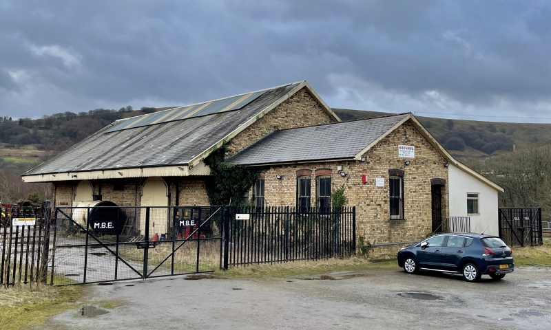
The goods shed is probably contemporary with the opening of Abersychan and Talywain station on 1/5/1878. The line on which it was built was jointly used by the London and North Western Railway which constructed it and the Monmouthshire Railway and Canal Company; though traffic from the south was run by the Great Western Railway (which took over the M.R. and C.C. in 1880) from the start. This would certainly appear to be an LNWR designed goods shed, but facilities at the station were shared by the two companies. The station and goods shed is shown on the 1879 O.S. map, but not the connection to the GWR from the south. The station was closed to passengers in 1941, and for freight in 1965.
Built of yellow possibly Ebbw Vale or Blaendare bricks, with red brick window arches and a Welsh slate roof. Single cell goods shed with an attached office at the north end. Five bay shed with the bays expressed by windows and pilasters on the trackside elevation. This has a plinth and strip pilasters framing panels each of which has an iron framed segmental headed window. The road elevation has two large double doors with diagonal boarding in segmental heads, with a window as above between. Projecting canopy on brackets over the loading bays. Plain roof with bargeboards and large ridge light. The south gable has an arched door for through running, now blocked. The north gable has a three bay single storey office projecting off-centre with a single and a paired two over two sash in segmental heads, with another one and a door on the gable end. Plain roof with brick stack. A modern extension to this on the west side masks the through running doorway into the main shed.
Included as a scarce example of an unaltered LNWR goods shed of the 1870's and for its historic interest as a survivor of the Abersychan and Talywain station.
External links are from the relevant listing authority and, where applicable, Wikidata. Wikidata IDs may be related buildings as well as this specific building. If you want to add or update a link, you will need to do so by editing the Wikidata entry.


Other nearby listed buildings
