History in Structure

Chimney

A Grade II Listed Building in Abersychan, Torfaen

More Photos »
Approximate Location Map
Large Map »

Coordinates

Latitude: 51.7239 / 51°43'25"N

Longitude: -3.0876 / 3°5'15"W

OS Eastings: 324974

OS Northings: 203354

OS Grid: SO249033

Mapcode National: GBR J2.2L28

Mapcode Global: VH79K.FXLV

Plus Code: 9C3RPWF6+GX

Entry Name: Chimney

Listing Date: 28 July 1997

Last Amended: 28 July 1997

Grade: II

Source: Cadw

Source ID: 18591

Building Class: Industrial

ID on this website: 300018591

Location: About 500m to the west of The British on the south side of the mountain road to Abertillery.

County: Torfaen

Town: Pontypool

Community: Abersychan

Community: Abersychan

Locality: The British

Traditional County: Monmouthshire

Tagged with: Architectural structure

Find accommodation in
Pontypool

History

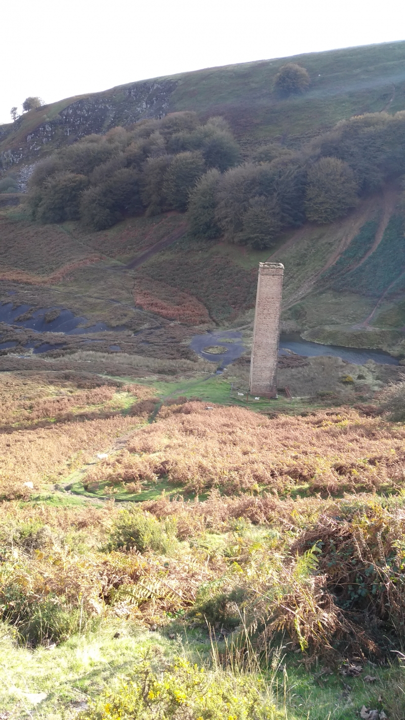
Probably dating from 1870-1879 and built as a ventilation shaft for the adjacent Cwm-Byrgwm colliery. The Ordnance Survey map of 1879 shows it in position. Mining began here before 1820.

Exterior

Tall square section chimney over a ventilation shaft. It is built of yellow, possibly Ebbw Vale or Blaendare bricks. Plain tapering shaft except for slightly larger section cap and coping.

Reasons for Listing

Included as a rare surviving colliery ventilation shaft in an area of deep mining, relics of which have now almost disappeared.

External Links

External links are from the relevant listing authority and, where applicable, Wikidata. Wikidata IDs may be related buildings as well as this specific building. If you want to add or update a link, you will need to do so by editing the Wikidata entry.

Recommended Books

Other nearby listed buildings

  • II Former colliery engine house at ETM Steel Fabrication
    On the south-east side of the Varteg to Llanhilleth mountain road at The British. The engine house backs onto the road and faces the yard behind.
  • II* Former British Ironworks office and foundry quadrangle
    The most prominent building in the area of the former British Ironworks, about 1000m south west of St Thomas's Church, Talywain.
  • II British Colliery Pumping Engine House
    On the site of the British Ironworks about 100m north east of the former British Ironworks office and foundry quadrangle.
  • II The Big Arch
    Located next to the B4246 and carries a disused railway embankment across a disused railway line now a track. The arch forms the visual and actual gateway to the former British Ironworks area.
  • II Former Goods Shed of Abersychan and Talywain Station
    To the west of Talywain village, high on the embankment above The British and about 300m north of the Big Arch.
  • II Church of St Thomas
    In the centre of Talywain standing in an extensive rectangular rubble walled churchyard.
  • II High Street Baptist Church
    Built backing into the hillside on a high platform with stone retaining wall and iron railings on a site overlooking Cwmsychan.
  • II Waterloo Cottage
    In the Talywain area of Abersychan, Waterloo Cottage is at the southern end of Fairfield (off Waterloo Road), where the road becomes a footpath.

BritishListedBuildings.co.uk is an independent online resource and is not associated with any government department. All government data published here is used under licence. Please do not contact BritishListedBuildings.co.uk for any queries related to any individual listed building, planning permission related to listed buildings or the listing process itself.

British Listed Buildings is a Good Stuff website.