History in Structure

Jones Family Tomb in the churchyard of St Mary's Church

A Grade II Listed Building in New Inn, Torfaen

More Photos »
Approximate Location Map
Large Map »

Coordinates

Latitude: 51.6855 / 51°41'7"N

Longitude: -2.9985 / 2°59'54"W

OS Eastings: 331070

OS Northings: 198996

OS Grid: ST310989

Mapcode National: GBR J5.54GC

Mapcode Global: VH79S.ZW6S

Plus Code: 9C3VM2P2+5J

Entry Name: Jones Family Tomb in the churchyard of St Mary's Church

Listing Date: 7 August 1997

Last Amended: 7 August 1997

Grade: II

Source: Cadw

Source ID: 18731

Building Class: Religious, Ritual and Funerary

ID on this website: 300018731

Location: In the churchyard of the Church of St Mary about 25m south of the south porch.

County: Torfaen

Town: Pontypool

Community: New Inn

Community: New Inn

Locality: Panteg

Built-Up Area: Pontypool

Traditional County: Monmouthshire

Tagged with: Tomb

Find accommodation in
Pontnewydd

History

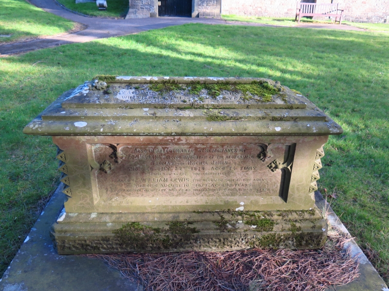
The style of the tomb suggests a date of c1865, but the earliest legible inscription is 1878.

Exterior

Chest tomb of grey limestone in the Gothic style. Vermiculated base, moulded plinth. Corners with dog-tooth ornamentation. Rolled cornice, stepped cap with relief cross. Long sides have sunk panels with inscriptions to the Jones family, on one side to Thomas and Rachel Jones, the date is illegible but is probably c1865. On the other side a better preserved inscription to Martha Jones, died 1878 and her brother William Lewis Jones also died 1878. Both were the children of Thomas and Rachel Jones.

Reasons for Listing

Included for group value with the Church of St Mary, and as a good and well preserved example of a mid/late C19 monument in the Gothic style.

External Links

External links are from the relevant listing authority and, where applicable, Wikidata. Wikidata IDs may be related buildings as well as this specific building. If you want to add or update a link, you will need to do so by editing the Wikidata entry.

Recommended Books

Other nearby listed buildings

  • II Tomb of William Jacob in St Mary's Churchyard
    In the Churchyard at the Church of St Mary, about 30m west of the tower.
  • II Church of St Mary
    To the east of New Inn about 500m from the junction of The Highway and Jerusalem Lane.
  • II Church Farmhouse
    To the east of New Inn village on the lane leading to the church of St Mary, Panteg.
  • II Barn at Ty-coch Farm
    About 250m south of the southern entry to New Inn village, and about 20m west of Ty-coch Farmhouse.
  • II Lower Trostra
    Off the south side of Glascoed Lane about 2000m south west of Glascoed crossroads in the direction of New Inn.
  • II Pentwyn Farmhouse
    Approached down a track off the north side of the road to Coed-y-paen, beyond Llanddewi Courtand about 1300m north east of the roundabout on the A4042.
  • II* Llanddewi Court
    Approached down a track off the north side of the road to Coed-y-paen and about 1300m north east of the roundabout on the A4042.
  • II Oxhouse at Llanddewi Court
    Attached to the south wing of Llanddewi Court farmhouse.

BritishListedBuildings.co.uk is an independent online resource and is not associated with any government department. All government data published here is used under licence. Please do not contact BritishListedBuildings.co.uk for any queries related to any individual listed building, planning permission related to listed buildings or the listing process itself.

British Listed Buildings is a Good Stuff website.