Approximate Location Map
Large Map »
Latitude: 51.4736 / 51°28'24"N
Longitude: -3.7009 / 3°42'3"W
OS Eastings: 281962
OS Northings: 176332
OS Grid: SS819763
Mapcode National: GBR H7.LFS5
Mapcode Global: VH5HN.S7T5
Plus Code: 9C3RF7FX+CJ
Entry Name: The Breakwater
Listing Date: 17 February 1998
Last Amended: 17 February 1998
Grade: II
Source: Cadw
Source ID: 19362
Building Class: Maritime
ID on this website: 300019362
Location: The outer arm of Porthcawl Harbour adjoining the E end of The Esplanade.
County: Bridgend
Town: Porthcawl
Community: Porthcawl
Community: Porthcawl
Locality: Porthcawl Harbour
Built-Up Area: Porthcawl
Tagged with: Architectural structure
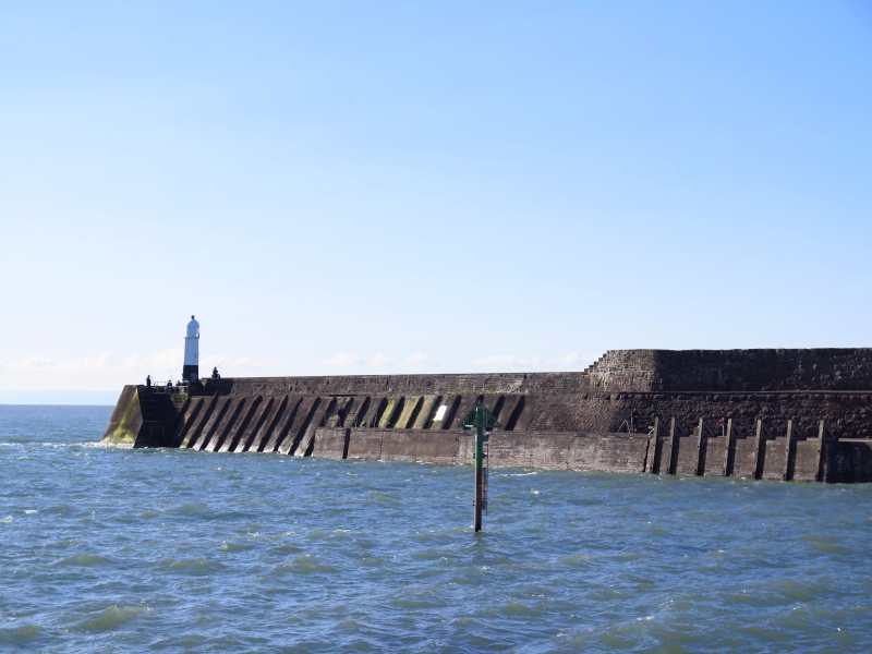
Construction of the harbour was authorised by Act of Parliament in 1825 to provide outlet for iron and coal from the Llynfi Valley, the material being transported by the Dyffryn Llynfi Porthcawl horsedrawn tramroad opened 1828. At this time the dock consisted of a rectangular basin with breakwater planned but not completed immediately because of financial difficulties, though shown extant on plan of 1846. Jennings warehouse constructed 1832. Section of rails of Dyffryn Llynfi Porthcawl Railway Company still in situ on Breakwater, the only such surviving. In 1864 John Brogden and Son, who had purchased Tondu Ironworks in the Llynfi Valley and were developing coal mining in the Ogmore Valley, were instrumental in obtaining an Act of Parliament for the improvement of Porthcawl Harbour which also involved extending the breakwater by 100 yds (91.4 metres). This was needed to provide additional protection for shipping as strong tides and winds had always made access difficult and in early stages dock could only be used spasmodically and predominantly in summer. Lighthouse established 1866 as part of these improvements. Photograph of 1865 shows Breakwater extension nearing completion with wooden structure (wood from Forest of Dean) part faced in stone. Following decades were the Dock's busiest, in 1874 shipping over 136,000 tons (138,720 tonnes) and docking over 700 vessels, trade mostly being within the British Isles. Over a half of the outgoing cargoes were from Brogden undertakings, many incoming vessels came in light or in ballast. Opening of Port Talbot and Barry Docks in 1898 led to almost total loss of trade at Porthcawl Dock which was closed in 1906. Subsequently harbour used for pleasure trips especially by paddle steamers in the Bristol Channel as Porthcawl became an increasingly popular resort. Narrow slipway shown in etching pre 1879, widened during 2nd World War to provide access for rescue service for ditched aircarft. Concrete reinforcement of seaward end dates from 1970s.
The Breakwater consists of a long arm stretching roughly E/W. Originally constructed of giant dressed stone blocks on a wooden frame, with smaller stone and other material such as brick and concrete used for later repairs, patching and alterations. On the landward side it is 3 tiered. Main quay is of stone blocks with plenty of later patching ; concrete surface covers original stone quay surface. Slipway in front widened and reinforced with later concrete. Second ramped and battered tier, also with giant blocks, incorporates a small surviving section of the Dyffryn Llynfi Porthcawl Railway imbedded in the stone surface, the rest covered in concrete. Top tier is the sea-wall mostly of smaller stone though some larger in centre, stepped up in centre; flights of stone steps join levels. Seaward end section is battered and faced in concrete though the lighthouse has a stone surround with stone ledges; flight of steps descends at end to water. On seaward side the defences rise at roughly 45% angle comprising a slope of giant roughly hewn and mortared boulders surmounted by 2 vertical courses of giant dressed blocks. Added concrete walkway with blue brick on top. Steps rise to the single width wall, here consisting of large stone blocks at base, small at top.
Included as a substantially surviving structure from the main period of activity of Porthcawl Dock in the second half of the C19 and for its crucial importance in the development of Porthcawl town ; group value with the Outer Basin, Jennings Warehouse, the Look-out Tower, the Old Customs House and the Lighthouse, the two latter actually standing on the Breakwater.
External links are from the relevant listing authority and, where applicable, Wikidata. Wikidata IDs may be related buildings as well as this specific building. If you want to add or update a link, you will need to do so by editing the Wikidata entry.


Other nearby listed buildings
