Approximate Location Map
Large Map »
Latitude: 52.9567 / 52°57'24"N
Longitude: -3.0849 / 3°5'5"W
OS Eastings: 327212
OS Northings: 340474
OS Grid: SJ272404
Mapcode National: GBR 72.KM5F
Mapcode Global: WH785.LY66
Plus Code: 9C4RXW48+M2
Entry Name: Farm Building at Fron-uchaf Farm, with front garden wall
Listing Date: 29 July 1998
Last Amended: 29 July 1998
Grade: II
Source: Cadw
Source ID: 20262
Building Class: Agriculture and Subsistence
ID on this website: 300020262
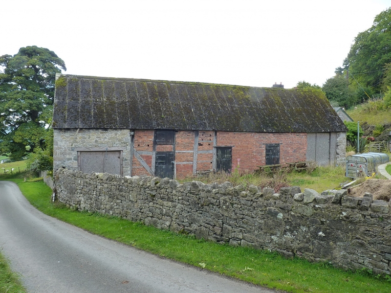
Location: The farm lies on the hill road from Fron-isaf to Froncysyllte. The farm building stands at right angles to the road, and forms the N side of the walled front garden.
County: Wrexham
Town: Wrexham
Community: Chirk (Y Waun)
Community: Chirk
Locality: Fron-isaf
Traditional County: Denbighshire
Tagged with: Agricultural structure
Probably built in the late C17 or C18, and altered in the early and later C19.
The building which combines the functions of barn, cowhouse and cartshed, is of stone, with a corrugated asbestos cement roof. Timber framing exposed above plate level on the gable end. The N side faces the farmyard, and was originally largely of timber framing infilled with brick, much replaced C19-early C20 with red brick. The bay nearest the road is of stone, forming a cartshed. A further opening is at the W end. The S side, facing the garden, has 2 tiers of ventilation slits. The gable end has a tie beam, queen struts and collar supporting a single tier of purlins. The garden wall containing the front garden on the E and S is of stone, with a stone-on-edge coping, and central gate.
Included as a well preserved farm building, of group value with the farmhouse and garden wall.
External links are from the relevant listing authority and, where applicable, Wikidata. Wikidata IDs may be related buildings as well as this specific building. If you want to add or update a link, you will need to do so by editing the Wikidata entry.


Other nearby listed buildings
