History in Structure

Gates and arch to Church of St. Cyngar

A Grade II Listed Building in Llangefni, Isle of Anglesey

More Photos »
Approximate Location Map
Large Map »

Coordinates

Latitude: 53.2579 / 53°15'28"N

Longitude: -4.3123 / 4°18'44"W

OS Eastings: 245852

OS Northings: 375926

OS Grid: SH458759

Mapcode National: GBR HNQ2.X0H

Mapcode Global: WH42T.QCQS

Plus Code: 9C5Q7M5Q+53

Entry Name: Gates and arch to Church of St. Cyngar

Listing Date: 16 October 1998

Last Amended: 16 October 1998

Grade: II

Source: Cadw

Source ID: 20548

Building Class: Religious, Ritual and Funerary

ID on this website: 300020548

Location: Located at the entrance to the churchyard and c. 25m ESE of the church of St. Cyngar.

County: Isle of Anglesey

Town: Llangefni

Community: Llangefni

Community: Llangefni

Built-Up Area: Llangefni

Traditional County: Anglesey

Tagged with: Gate

Find accommodation in
Llangefni

History

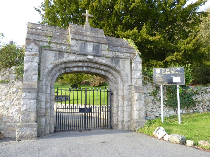
Dated 1890, the year following the erection of the chancel to the church of St. Cyngar.

Exterior

Perpendicular style gateway built of rock-faced limestone masonry, set within the rubble churchyard wall. A double gateway is set into a wide, elliptical-headed arch of 3 orders with hoodmould. There is a datestone centred over the arch, inscribed A. D. 1890; the gabled roof is stepped up over the datestone and is surmounted by a plain masonry cross. Flanking the arch are slightly offset angle buttresses; the arch itself is hung with simple, cast-iron gates, with tall and short alternating vertical rails.

Reasons for Listing

Included as a striking example of a church gateway, bold in design and construction, and which forms a group with the adjacent church of St. Cyngar.

External Links

External links are from the relevant listing authority and, where applicable, Wikidata. Wikidata IDs may be related buildings as well as this specific building. If you want to add or update a link, you will need to do so by editing the Wikidata entry.

Recommended Books

Other nearby listed buildings

  • II Church of St. Cyngar
    Set back from the NW side of the B5111 Lon Las at the N end of Llangefni. The church is in an elevated location within grounds to the N of the Afon Cefni.
  • II The Market Hotel
    Located on the N side of Bulkeley Square, directly opposite the Bull Hotel.
  • II Former National School and Schoolhouse
    In an elevated location, set back from the NE side of the western end of the main street through Llangefni; c. 200m SW of the church of St. Cyngar.
  • II Town Clock
    Set directly in front of the Town Hall, at the S side of Bulkeley Square in the centre of Llangefni.
  • II The Bull Hotel, including stable courtyard to rear.
    Located at the SW corner of Bulkeley Square with side elevation to Glanhwfa Road.
  • II Town Hall
    Located at the S side of Bulkeley Square, and set back from the main street in the centre of Llangefni; c.400m SSE of the church of St. Cyngar.
  • II Llangefni County School War Memorial
    Set back on the S side of Cildwrn Road in the grounds of the former Llangefni County School.
  • II Doldir
    About half way down the road, to N (L) of Capel Moriah.

BritishListedBuildings.co.uk is an independent online resource and is not associated with any government department. All government data published here is used under licence. Please do not contact BritishListedBuildings.co.uk for any queries related to any individual listed building, planning permission related to listed buildings or the listing process itself.

British Listed Buildings is a Good Stuff website.