Approximate Location Map
Large Map »
Latitude: 51.8485 / 51°50'54"N
Longitude: -3.1537 / 3°9'13"W
OS Eastings: 320625
OS Northings: 217282
OS Grid: SO206172
Mapcode National: GBR F0.TLCT
Mapcode Global: VH6CH.9S3T
Plus Code: 9C3RRRXW+9G
Entry Name: Bank of Limekilns
Listing Date: 21 October 1998
Last Amended: 21 October 1998
Grade: II*
Source: Cadw
Source ID: 20706
Building Class: Commercial
ID on this website: 300020706
Location: Located immediately N of Upper Yard Bridge (Canal Bridge No 115), on the W side of the Monmouthshire and Brecon Canal.
County: Powys
Community: Llangattock (Llangatwg)
Community: Llangattock
Locality: Llangattock Wharf
Built-Up Area: Llangattock
Traditional County: Brecknockshire
Tagged with: Lime kiln
The Brecknock and Abergavenny Canal was proposed in 1792 to connect the Upper Usk valley to the Monmouthshire Canal at Pontymoile and from there to the sea at Newport. The middle section of the canal, between Gilwern and Talybont and including Llangattock, was cut between 1797 and 1799.
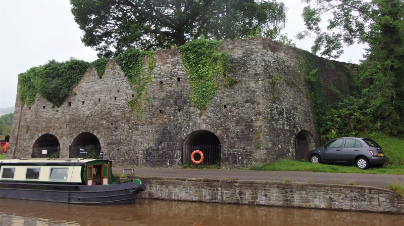
From 1815, limestone was brought down by tramroad from the Llangattock quarries by the Brecknock Boat Co. The Company built these kilns at the same time in order to produce lime for the export market. A butt joint in the structure suggests that they were enlarged later. In 1865 the limekilns were taken over by the Monmouthshire Railway & Canal Co, but by the 1870s they had gone out of use as a result of railway competition. Restored in the late C20.
A large, high bank of continuous limekilns of trapezoidal plan. Probably rectangular originally with 7 draw hole vaults. Later addition to the N with a further 2 draw hole vaults. Battered walls constructed of rubble sandstone. The draw hole vaults are to the S, E and NE sides, whilst the kilns are built into the rising hillside to the W. On the top surface, 1 kiln bowl is still visible.
The S wall has 2 pairs of draw hole vaults offset to the L, all round arched with voussoirs and large keystones. The pairs are separated by a large battered buttress, with smaller buttresses between each pair and at the W end. To the R is a wide stepped projection, with an entrance into its E side. This contains a half arch with voussoirs, partially blocked, leading into a chamber. From here, is a further arch to the N leading into a 5th draw hole vault. There is a pier to the SE angle, possibly for additional support. The E side faces the canal and originally had 2 similar draw hole vaults symmetrically placed. There are lines of small recesses in the masonry above, probably breathers. An additional kiln was built onto the N side, shown by a butt joint in the E wall. Its NE angle is obtuse with quoins. There are 2 draw hole vaults, to the E and NE sides, with small round arches and red sandstone voussoirs. There are breathers above, but they are not aligned with those to the S.
The original kilns have tunnel vaults. The rear walls each contain 2 draw-eyes, now blocked with stone, with iron lintels above. The E and NE draw hole vaults of the extension lead to a vault behind the obtuse NE angle of the structure. The rear (SW) masonry wall of this vault contains 4 draw-eyes under cast iron lintels, supported by brick and partially rebuilt. Behind these openings, the shaft of the kiln bowl can be seen rising upwards. On the top surface, the brick-lined kiln bowl is sub-rectangular in plan and tapers inwards towards the base. It is deep, suggesting a continuous kiln, and has been rebuilt in places in firebrick. As this chamber belongs to the later addition, there must have been at least one further kiln bowl to the S.
Listed grade II* as an exceptionally well preserved bank of early C19 limekilns associated with the Brecknock and Abergavenny Canal and the tramroad from the Llangattock quarries.
Group value with neighbouring listed items associated with Llangattock Wharf.
External links are from the relevant listing authority and, where applicable, Wikidata. Wikidata IDs may be related buildings as well as this specific building. If you want to add or update a link, you will need to do so by editing the Wikidata entry.


Other nearby listed buildings
