History in Structure

Michaelston Bridge (partly in Michaelston-y-Fedw Community)

A Grade II Listed Building in Rudry, Caerphilly

More Photos »
Approximate Location Map
Large Map »

Coordinates

Latitude: 51.5631 / 51°33'47"N

Longitude: -3.0944 / 3°5'39"W

OS Eastings: 324237

OS Northings: 185480

OS Grid: ST242854

Mapcode National: GBR J1.DQCX

Mapcode Global: VH7BB.9ZZ3

Plus Code: 9C3RHW74+67

Entry Name: Michaelston Bridge (partly in Michaelston-y-Fedw Community)

Listing Date: 5 March 1999

Last Amended: 5 March 1999

Grade: II

Source: Cadw

Source ID: 21439

Building Class: Transport

ID on this website: 300021439

Location: Crossing the River Rhymney on N side of Michaelston-y-Fedw village and carrying a minor road between Michaelstone and Draethen.

County: Caerphilly

Community: Rudry (Rhydri)

Community: Rudry

Locality: Llanfedw

Traditional County: Glamorgan

Tagged with: Bridge

Find accommodation in
Castleton

History

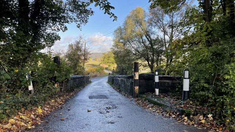
Probably an C18 bridge but rebuilt in early C19 and shown in its present form on the 1839 Llanfedw Tithe map. In detail it is similar to Cefn Mably Bridge.

Exterior

Single-carriageway 2-span bridge in vernacular style, principally of snecked rubble stone. Segmental arches have fine arch rings, with a string course above the arches on the upstream side. The central pier has V-shaped cutwaters with shallow offsets, rising the full height of the parapet and defining refuges. The low parapet has a flat stone coping and is splayed out at the ends above the splayed abutments. The deck is laid with tarmac and is ramped from N to S.

Reasons for Listing

A well-preserved early C19 road bridge, one of a pair with Cefn Mably Bridge.

External Links

External links are from the relevant listing authority and, where applicable, Wikidata. Wikidata IDs may be related buildings as well as this specific building. If you want to add or update a link, you will need to do so by editing the Wikidata entry.

Recommended Books

Other nearby listed buildings

  • II Michaelstone Bridge
    Located to the North of Michaelstone-Y-Fedw village, crossing the River Rhymni, leading to Ruperra Castle; a pair with Cefn Mably Bridge.
  • II* Parish Church of St Michael
    Located at the W side of the village, within a C19 walled enclosure, set behind the public house.
  • II The Old Rectory
    Set on the East side of the lane, opposite the Public House and the Parish Church. Main range is aligned on a NW/SE axis.
  • II Barn at Gwern Leyshon Farm
    Approximately 1.8km SE of Draethen village, reached by short farm road on E side of a minor road between Draethen and Michaelston-y-Fedw. The barn faces W to the farmyard with house on its N side.
  • II 'New Mansion' at Ruperra Home Farm
    On open hillside E of Ruperra Home Farm, and reached by a farm road on W side of minor road between Michaelston-y-Fedw and Draethen.
  • II Cefn Mably Bridge
    Located on the lane leading from Michaelstone village to Cefn Mably crossing the River Rhymni, a pair with Michaelstone Bridge.
  • II Cefn Mably Bridge (also known as Cefn Llwyd Bridge) (partly in Michaelston-y-Fedw Community)
    Road bridge over River Rhymney approximately 1km W of Michaelston-y-Fedw Church and carrying a minor road between Michaelston-y-Fedw and Cefn Mably

BritishListedBuildings.co.uk is an independent online resource and is not associated with any government department. All government data published here is used under licence. Please do not contact BritishListedBuildings.co.uk for any queries related to any individual listed building, planning permission related to listed buildings or the listing process itself.

British Listed Buildings is a Good Stuff website.