Approximate Location Map
Large Map »
Latitude: 51.4435 / 51°26'36"N
Longitude: -3.6011 / 3°36'3"W
OS Eastings: 288824
OS Northings: 172823
OS Grid: SS888728
Mapcode National: GBR HC.N8Y3
Mapcode Global: VH5HQ.JZMB
Plus Code: 9C3RC9VX+9H
Entry Name: Garden Building
Listing Date: 3 March 1999
Last Amended: 3 March 1999
Grade: II
Source: Cadw
Source ID: 21788
Building Class: Gardens, Parks and Urban Spaces
ID on this website: 300021788
Location: The front wall of the building is incorporated into the S boundary of the walled gardens. The house was on top of the hill above (S) and its gateway is visible.
County: Vale of Glamorgan
Community: St. Bride's Major (Saint-y-Brid)
Community: St. Bride's Major
Locality: Dunraven Park
Traditional County: Glamorgan
Tagged with: Architectural structure
Dunraven Castle, an early C19 castellated gothic-style mansion, was situated on a cliff top overlooking the sea. The site has a long and almost continuous history, starting as an Iron Age hillfort. A Norman castle here was awarded to the de Londres family of Ogmore, and then to the Butlers. It was probably rebuilt in the C15 as a manor house, and recorded thus by Leland in the 1530s as a ‘the manor place’. It is shown in an engraving of c 1776 with features such as mullioned windows. At this time it is said to have included many of the older elements including a chapel and burial place. It passed to the Vaughans, then to the Wyndham family in the C16, and finally to the Earls of Dunraven.
The castle was rebuilt in 1802-6 by Thomas Wyndham of Clearwell Castle, Gloucestershire, as a hunting seat. The design was drawn up by Mrs Wyndham, though it appears to be based on the design for Clearwell Castle, by Roger Morris, 1728. It was remodelled in 1858 by Egbert Moxham, for Caroline Wyndham; the central tower was replaced by a conservatory and the N and S wings were raised. It was extended with a tower and wing on the seaward side by George Devey in 1886-8. The castle was demolished in 1962, having been used as a hotel, and only the footings survive.
The park was a deer park in the C17. The park walls, lodges, entrances and drives are probably contemporary with the rebuilding of the house in 1802-6. The sea walks in the park were designed by Lord Dunraven in 1840.
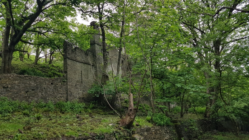
The building appears to have been constructed by c 1830 and it is shown in a view by Neale. Not shown on an engraving of 1776. It appears to have been a folly.
The building has a 2-storey central unit flanked by lower wings. Constructed of random masonry with corbelled, battlemented parapets. Tall pilasters to each side of the high central unit giving the appearance of clasping buttresses. Blocked central entrance under a round brick-arched head, flanked by single-light round-arched window openings (that to the R obscured by vegetation). Above the front door is a blocked roundel. There are similar aligned windows in the upper storey. The fronts of the flanking wings have narrow central lancets. The central unit projects into the bank which rises to the S and is one storey high. There is a round arched opening into the E side.
No access at time of inspection (December 1997).
Listed as a good example of a C19 garden folly.
Group value with walled garden and other listed items in Dunraven Park.
External links are from the relevant listing authority and, where applicable, Wikidata. Wikidata IDs may be related buildings as well as this specific building. If you want to add or update a link, you will need to do so by editing the Wikidata entry.


Other nearby listed buildings
