History in Structure

The Pound

A Grade II Listed Building in Llansadwrn, Carmarthenshire

More Photos »
Approximate Location Map
Large Map »

Coordinates

Latitude: 51.966 / 51°57'57"N

Longitude: -3.9011 / 3°54'3"W

OS Eastings: 269488

OS Northings: 231435

OS Grid: SN694314

Mapcode National: GBR Y0.L70N

Mapcode Global: VH4HL.BVH6

Plus Code: 9C3RX38X+CH

Entry Name: The Pound

Listing Date: 29 July 1999

Last Amended: 29 July 1999

Grade: II

Source: Cadw

Source ID: 22111

Building Class: Agriculture and Subsistence

ID on this website: 300022111

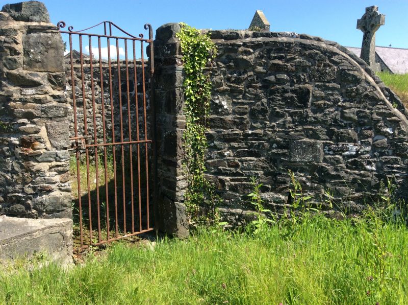
Location: Situated at SW entry to the churchyard of the Church of St Sadwrn, next to the War Memorial.

County: Carmarthenshire

Town: Llanwrda

Community: Llansadwrn

Community: Llansadwrn

Traditional County: Carmarthenshire

Tagged with: Architectural structure

Find accommodation in
Llansadwrn

History

Small pound for keeping stray animals, probably earlier C19.

Exterior

Pound, rubble stone circular walls some 2m high with rough coping. Tall narrow opening to S with iron gate. Cobbled floor within.

Reasons for Listing

Included for agricultural historical interest as a well-preserved example of the small village pounds which are a feature of the region.

External Links

External links are from the relevant listing authority and, where applicable, Wikidata. Wikidata IDs may be related buildings as well as this specific building. If you want to add or update a link, you will need to do so by editing the Wikidata entry.

Recommended Books

Other nearby listed buildings

  • II The War Memorial
    Situated at SW entry to churchyard of Church of St Sadwrn.
  • II Church of Saint Sadwrn
    Situated in rounded churchyard in centre of village.
  • II Capel Ebenezer
    Situated in village of Llansadwrn, just N of churchyard wall.
  • II The Old Vicarage
    Situated some 100m E of the churchyard, on N side of narrow lane.
  • II Myrtle Hill
    Situated some 50m N of the churchyard, on W side of road.
  • II Fountain House
    Situated some 100m E of churchyard, on S side of narrow lane.
  • II Seion
    Situated just N of village, some 150m N of churchyard, on E side of road.
  • II Cwm Mynydd Fach
    Situated on a steeply sloping site beside the by-road that runs from Llansadwrn towards Talley; approximately 1km NW of Llandsadwrn. Buttressed rubble wall to cobbled forecourt with lawns beyond.

BritishListedBuildings.co.uk is an independent online resource and is not associated with any government department. All government data published here is used under licence. Please do not contact BritishListedBuildings.co.uk for any queries related to any individual listed building, planning permission related to listed buildings or the listing process itself.

British Listed Buildings is a Good Stuff website.