Approximate Location Map
Large Map »
Latitude: 51.5838 / 51°35'1"N
Longitude: -3.0158 / 3°0'56"W
OS Eastings: 329715
OS Northings: 187705
OS Grid: ST297877
Mapcode National: GBR J5.CD3L
Mapcode Global: VH7BC.PG16
Plus Code: 9C3RHXMM+GM
Entry Name: East gates, piers and flanking walls to St Woolos Cemetery
Listing Date: 14 September 1999
Last Amended: 14 September 1999
Grade: II
Source: Cadw
Source ID: 22342
Building Class: Religious, Ritual and Funerary
ID on this website: 300022342
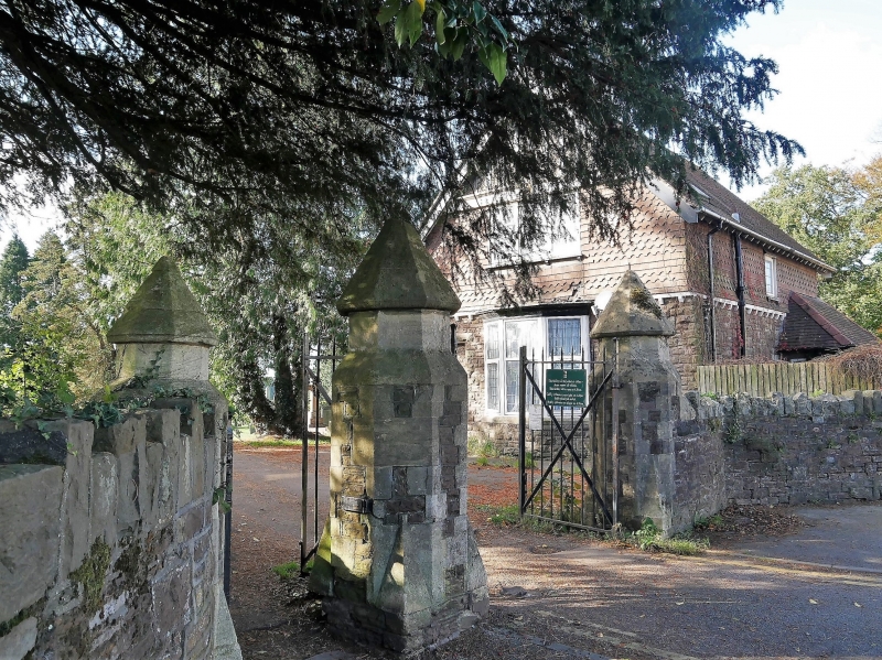
Location: St Woolos Cemetery has its main entrance off the north side of Bassaleg Road. The east gates are situated along Risca Road, immediately S of the eastern lodge.
County: Newport
Community: Allt-yr-yn (Allt-yr-ynn)
Community: Allt-yr-Yn
Locality: St Woolos
Built-Up Area: Newport
Traditional County: Monmouthshire
Tagged with: Wall Gate Gatepost Churchyard wall Cemetery gate
The site was purchased by the Newport Burial Committee from Lord Tredegar in February 1854, the first burial being on 18th July of that year. The competition to design the Nonconformist and Anglican Chapels, together with the lodge and gates was won by Johnson and Purdue, architects of London, the buildings completed in November 1855. Towards the middle of the C19, growing urban populations coupled with increased cholera outbreaks meant that many parish churchyards became notoriously unsanitary. In 1850, the government passed the Metropolitan Burial Act, which was extended in 1853 to England and Wales. The purpose of the Acts, which spanned 1850-57 was to ensure that public cemeteries were laid out, bodies buried in a dignified fashion, and that all burials were recorded. The setting out of cemeteries with elaborate gates, lodges and chapels for various denominations had already been initiated by the London-based General Cemetery Company, a private enterprise, which laid out Kensal Green Cemetery 1831-37. Kensal Green received much publicity, fuelling the increasing sentimentality in commemorating the dead. Following the Act of 1853 came a boom in cemetery building, Newport being the first public cemetery in Wales. The use of contrasting styles for the Nonconformist and Anglican chapels is unusual among the early public cemeteries, reflecting the strength of Nonconformity in Newport.
The Roman Catholics after some difficulty, gained an area on the north side of the cemetery by 1855, but it was not until c. 1880 that they built their own chapel, by which time the Jews had a small separate burial ground immediately to the north of the cemetery. The cemetery was extended to the SW by c. 1880, demarcated by the avenue of pine trees towards the W end of the site, and again in the early C20. The cemetery remains in use, the chapels and mortuary are now used for storage.
Carriage gates to right with pedestrian gate to left. Carriage gate has plain C20 iron gates with octagonal pier each side, built of red rubble sandstone with grey sandstone detail. Piers have broach stops. Short upper stages with blunt pyramidal copings. Pedestrian gate has similar and smaller pier to left: similar gate. Wall to right of carriage gate is of rubble construction with grey sandstone long-and-short copings: wall continues for approximately 1 metre before splaying out in line with pavement to join main cemetery boundary. Left wall splays out from left pier to line of pavement.
Listed as a prominent surviving feature of the first public cemetery in Wales.
External links are from the relevant listing authority and, where applicable, Wikidata. Wikidata IDs may be related buildings as well as this specific building. If you want to add or update a link, you will need to do so by editing the Wikidata entry.


Other nearby listed buildings
