Approximate Location Map
Large Map »
Latitude: 52.697 / 52°41'49"N
Longitude: -3.8099 / 3°48'35"W
OS Eastings: 277789
OS Northings: 312570
OS Grid: SH777125
Mapcode National: GBR 94.30MK
Mapcode Global: WH681.GG0S
Plus Code: 9C4RM5WR+Q3
Entry Name: Ceiswyn
Listing Date: 6 December 1999
Last Amended: 6 December 1999
Grade: II
Source: Cadw
Source ID: 22710
Building Class: Domestic
ID on this website: 300022710
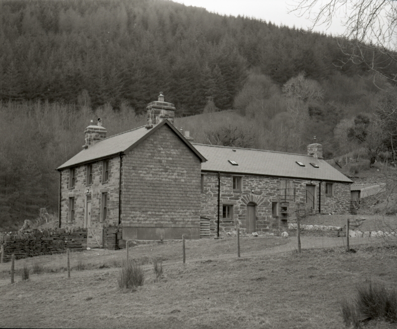
Location: The farm is the last dwelling in Cwm Ratgoed. It is sited uphill on a bank raised above the Afon Ceiswyn, and NW of Dugoed.
County: Gwynedd
Town: Machynlleth
Community: Corris
Community: Corris
Locality: Aberllefenni
Traditional County: Merionethshire
Tagged with: Architectural structure
The farmhouse consists of a long uphill sited range with the domestic part at the lower end, all probably C16 or early C17, to which has been added in the mid-late C19, a 2-storey cross wing expanding and upgrading the domestic accommodation. The house was the home of Sion Lloyd I (John David Lloyd) sheriff of the county 1557-1558, son-in-law and companion of Sir Lewys Owain at the time he was murdered by the brigands of Mawddwy. Ceiswyn was owned by Sir Watkin Williams Wynne at the time of the tithe apportionment, 1838, and occupied by David Evans. At that date it had over 15 acres (6.07ha).
The building is constructed of rubble, formerly whitewashed, with a slate roof. The front block is constructed with slate, with rock-faced quoins and window dressings, slate hung gable ends and a slate roof between gable stacks. The earlier section probably consists of a living kitchen reached through the voussoir-arched entrance door facing E, and an inner room, with a farm building and loft over, set uphill in line. External stone stair to the loft. One stack at the upper end of the range. The front range is of 2 storeys, 2 bay, with central entrance and two windows to each floor. All the windows are sheeted over.
Not accessible at the time of inspection. Reported by RCAHMW to have a lateral stack, post and panel partitions and an ornate open roof with cusping.
Included as the primary farm at the valley head which retains a traditional uphill siting and late medieval or sub-mediaeval character, expanded in the C19. Recorded as retaining a rare ornate cusped roof to an open hall.
External links are from the relevant listing authority and, where applicable, Wikidata. Wikidata IDs may be related buildings as well as this specific building. If you want to add or update a link, you will need to do so by editing the Wikidata entry.


Other nearby listed buildings
