History in Structure

Pont y Ceunant (partly in Llandygai community)

A Grade II Listed Building in Llanllechid, Gwynedd

More Photos »
Approximate Location Map
Large Map »

Coordinates

Latitude: 53.1582 / 53°9'29"N

Longitude: -4.0461 / 4°2'46"W

OS Eastings: 263286

OS Northings: 364295

OS Grid: SH632642

Mapcode National: GBR 5T.51LW

Mapcode Global: WH54G.TWG7

Plus Code: 9C5Q5X53+7G

Entry Name: Pont y Ceunant (partly in Llandygai community)

Listing Date: 9 March 2000

Last Amended: 9 March 2000

Grade: II

Source: Cadw

Source ID: 22974

Building Class: Transport

Also known as: Pont y Ceunant (partly in Llanllechid community)

ID on this website: 300022974

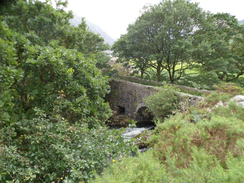
Location: Spanning the Afon Ogwen near the point where the minor road through Nant Ffrancon meets the A 5 at Tyn-y-maes.

County: Gwynedd

Community: Llanllechid

Community: Llanllechid

Locality: Tyn-y-maes

Traditional County: Caernarfonshire

Tagged with: Bridge Road bridge

Find accommodation in
Bethesda

History

Constructed on the course of the so-called "old road" along the remote Ogwen Valley, an improvement by the Penrhyn Estate in 1790-1 of what Thomas Pennant had described as "the most dreadfull horsepath in Wales". This road was effectively superseded as the main through route along the valley by the building of the turnpike road (the line of the present A5) on its eastern side in 1802. The Afon Ogwen here forms the boundary with the Llandygai community.

Exterior

Roughly coursed rubblestone with stone-on-edge coping. Twin arches, both round-headed with voussoirs and arch-rings.

Reasons for Listing

Included as a small late C18 bridge of traditional vernacular character, important also for the evidence it provides of improving transport and communications at this period.

External Links

External links are from the relevant listing authority and, where applicable, Wikidata. Wikidata IDs may be related buildings as well as this specific building. If you want to add or update a link, you will need to do so by editing the Wikidata entry.

Recommended Books

Other nearby listed buildings

  • II Pont y Ceunant (partly in Llanllechid community)
    Spanning the Afon Ogwen near the point where the minor road through Nant Ffrancon meets the A 5 at Tyn-y-maes.
  • II Slate fencing, rubblestone walling and privies at Ceunant
    Slate fencing and rubblestone walling defining boundaries of Ceunant; privies in cottage gardens.
  • II Outbuildings at Ceunant
    One outbuilding situated on main approach to cottages, other straddling southern boundary of left cottage.
  • II Ceunant
    Situated in remote position at end of short rough track running off the road directly to the north-east of Pont y Ceunant; there is a steep drop immediately to the west of the rear gardens of the cott
  • II Ty Ffrancon
    Situated immediately to north of Capel Bethel; low rubblestone wall to front breached by vehicular access.
  • II Capel Bethel
    Situated on eastern side of the A 5 at southern end of Tyn-y-maes; low rubblestone wall to front with slate coping and plain iron railings has slightly recessed entrance with square piers and iron gat
  • II Milestone
    Situated close to the track to Plas Penisarnant off the A 5 south of Bethesda; set directly on road abutting rubblestone boundary wall.
  • II* Plas Penisarnant
    At the foot of Nant Ffrancon, between the A5 and the river Ogwen, in wooded grounds.

BritishListedBuildings.co.uk is an independent online resource and is not associated with any government department. All government data published here is used under licence. Please do not contact BritishListedBuildings.co.uk for any queries related to any individual listed building, planning permission related to listed buildings or the listing process itself.

British Listed Buildings is a Good Stuff website.