Approximate Location Map
Large Map »
Latitude: 51.817 / 51°49'1"N
Longitude: -3.1143 / 3°6'51"W
OS Eastings: 323288
OS Northings: 213738
OS Grid: SO232137
Mapcode National: GBR F1.WQ55
Mapcode Global: VH6CP.YLZG
Plus Code: 9C3RRV8P+Q7
Entry Name: Tramroad Bridge near junction of A465 and Station Road
Listing Date: 27 July 2000
Last Amended: 27 July 2000
Grade: II
Source: Cadw
Source ID: 23818
Building Class: Transport
ID on this website: 300023818
Location: Bridge located within fork between Station Road and A465 Heads of the Valleys Road. Bridge now disused, due to road improvements. Approximately 2 km NE of Clydach.
County: Monmouthshire
Community: Llanelly (Llanelli)
Community: Llanelly
Locality: Clydach
Traditional County: Brecknockshire
Tagged with: Tram bridge
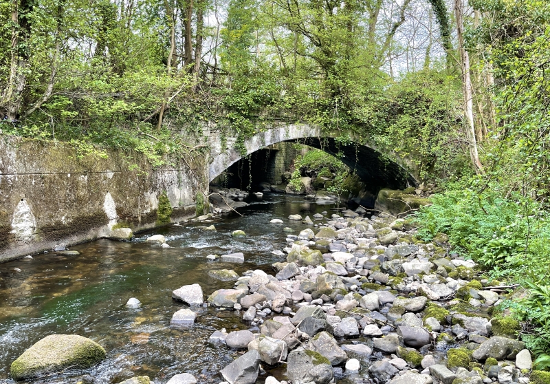
Built 1809-11 to carry the Llam-march tramroad, begun in 1794 by John Dadford, engineer. This section of tramroad was built to link the Brecknock and Abergavenny Canal at Gilwern to the collieries and iron-ore quarries at Llam-march, via the Clydach Ironworks, which was set up c. 1793 by Edward and John Kendall, who sub-let the works to Edward Frere and Thomas Cooke. The Brecknock and Abergavenny Canal Company resolved to allow Frere, Cooke and Edward Kendall to build a railroad on 28th May 1794 from Llam-march to the ironworks, the iron company paying a rental of 8% a year of the cost of construction and to be responsible for all repairs. By June 1795, the railroad was largely complete. In 1800, the Brecon and Abergavenny Canal was completed from Brecon to Gilwern, and by 1812, the canal was extended to link with the Monmouthshire Canal at Pontymoile, which enabled direct links with Newport and the Bristol Channel . With the expansion of the canal system, the Clydach Iron Company successfully applied in 1809 to extend the Llam-march tramroad to the canal at Gilwern, where they built a wharf and warehouse; this section of tramroad was completed in 1811. In 1960-62, the Abergavenny -Brynmawr section of the Heads of the Valleys Road was built (engineers Rendall, Palmer and Tritton), involving the provision of a new bridge over the Clydach and a new junction to Station Road, rendering the old tramroad bridge redundant
Rubble construction. Single segmental arch of impressive span with ashlar voussoirs. Parapets removed and replaced with C20 fence.
Listed as an impressively designed and well-preserved early C19 tramroad bridge, a prominent surviving structure of important industrial landscape of the Clydach Gorge.
External links are from the relevant listing authority and, where applicable, Wikidata. Wikidata IDs may be related buildings as well as this specific building. If you want to add or update a link, you will need to do so by editing the Wikidata entry.


Other nearby listed buildings
