Approximate Location Map
Large Map »
Latitude: 51.7645 / 51°45'52"N
Longitude: -2.854 / 2°51'14"W
OS Eastings: 341163
OS Northings: 207654
OS Grid: SO411076
Mapcode National: GBR JC.04TD
Mapcode Global: VH79H.HX27
Plus Code: 9C3VQ47W+QC
Entry Name: Raglan Post Office
Listing Date: 31 January 2001
Last Amended: 31 January 2001
Grade: II
Source: Cadw
Source ID: 24726
Building Class: Domestic
ID on this website: 300024726
Location: Prominently sited on the High Street in Raglan.
County: Monmouthshire
Town: Raglan
Community: Raglan (Rhaglan)
Community: Raglan
Built-Up Area: Raglan
Traditional County: Monmouthshire
Tagged with: Post office
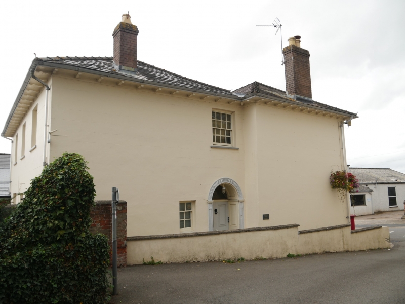
Early C19 house originally known as Raglan House, by the late C19 developed into a shop, called the Old Shop, advertised on an outbuilding behind No 3 High Street as flour, corn, seed, beer and porter stores. Renovated, the front ground floor made into single shop and the rear converted to flats in late C20 when the Post Office moved here from Castle Street.
Early C19 house with later C20 shop front. Painted stucco with hipped slate roof and curved brackets to flat eaves. C20 pink brick end stacks to both ranges of double-pile plan. Two-storey, 4 window range of 12-pane hornless sash windows to front, the ground floor left 2 bays replaced by the C20 shopfront. The rear range is slightly shorter, the recessed W end with original arched main doorway. Reeded jambs and arch, panelled reveals and soffit, traceried fanlight and 4-panel door with raised and fielded panels. Renewed 16-pane sash over and C20 small window left. Rear has 3-window range of renewed 16-pane sashes over centre 16-pane sash and outer 4-12-4-pane tripartite sashes.
Altered in conversion, ground floor front a single retail unit.
Included as a substantial early C19 village house retaining much of its external character.
External links are from the relevant listing authority and, where applicable, Wikidata. Wikidata IDs may be related buildings as well as this specific building. If you want to add or update a link, you will need to do so by editing the Wikidata entry.


Other nearby listed buildings
