Approximate Location Map
Large Map »
Latitude: 51.7616 / 51°45'41"N
Longitude: -2.7028 / 2°42'10"W
OS Eastings: 351589
OS Northings: 207219
OS Grid: SO515072
Mapcode National: GBR JL.06TC
Mapcode Global: VH871.3ZGG
Plus Code: 9C3VQ76W+JV
Entry Name: Fernside Mill
Listing Date: 28 February 2001
Last Amended: 4 November 2020
Grade: II
Source: Cadw
Source ID: 24948
Building Class: Industrial
ID on this website: 300024948
Location: On the north side of the Whitebrook valley road and about 2km west of the Church of the Holy Trinity.
County: Monmouthshire
Town: Monmouth
Community: Trellech United (Tryleg Unedig)
Community: Trellech United
Locality: Whitebrook
Traditional County: Monmouthshire
Tagged with: Mill
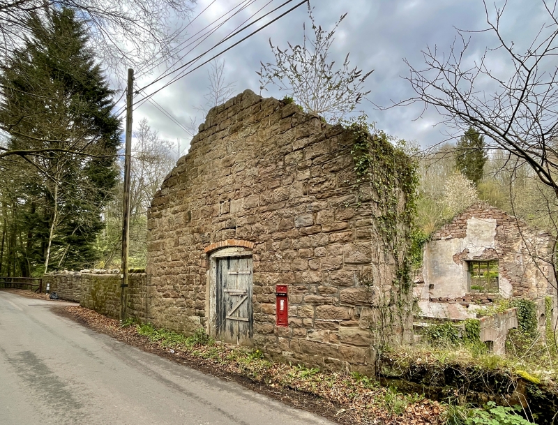
This is the only complete paper mill surviving in the Whitebrook valley and very possibly the only one left in Wales. It is not known when it was built, but it appears early C19 in architectural character and it was certainly in existence in 1842. All the paper mills in the valley seem to have gone out of production soon after the Wye Valley Railway opened in 1876. Water power was by then no longer needed and the railways meant that the necessary rags could easily be collected to the central industrial areas, and this also coincided with the great increase in the use of wood fibre in paper making which required large premises and mechanical production.
This former mill building is now roofless and in extremely poor condition. The three-storey structure was built backing onto the mill dam. The former top floor is level with the road and has direct access to it through the gable end. The other two floors were below the water level in the mill pond, giving a 5m head.
The building is constructed of coursed squared rock faced local sandstone rubble and although the roof has gone the gable ends remain in place. The south-west, roadside, gable end has an elliptically-headed boarded door and an inset Victorian (VR) wall post box. The elevation onto the millpond (north-west) is single storey but the former timber frame, with vertical louvres, is lost. This was a diagnostic feature of the former mill as the louvres were there to ventilate the paper drying floor. The downstream (south-east) elevation is three storeys and had two doors and three windows on the ground floor and five windows on the first floor. The elliptical heads and openings remain but most of the windows have gone and some of the ground floor openings are blocked up. The upper floor has entirely gone.
The original plan of drying floor at the top, paper making floor in the middle and rag floor to the base is no longer discernible following internal collapse and the building’s progressively ruinous state.
Included notwithstanding its very poor condition on account of its historic interest and industrial heritage significance. It is a very rare example in Wales of a paper mill, believed to be the only one of its kind still surviving in some form.
External links are from the relevant listing authority and, where applicable, Wikidata. Wikidata IDs may be related buildings as well as this specific building. If you want to add or update a link, you will need to do so by editing the Wikidata entry.


Other nearby listed buildings
