Approximate Location Map
Large Map »
Latitude: 51.4941 / 51°29'38"N
Longitude: -3.3016 / 3°18'5"W
OS Eastings: 309732
OS Northings: 178040
OS Grid: ST097780
Mapcode National: GBR HS.K075
Mapcode Global: VH6F4.QQD0
Plus Code: 9C3RFMVX+J8
Entry Name: St-y-Nyll
Listing Date: 7 August 2002
Last Amended: 7 August 2002
Grade: II
Source: Cadw
Source ID: 26822
Building Class: Domestic
ID on this website: 300026822
Location: In a commanding position on a south facing slope N of St Bride's-super-Ely, close to the listed windmill to E, surrounded by gardens and reached by a drive.
County: Vale of Glamorgan
Community: St. Georges-super-Ely (Sain Siorys)
Community: St. Georges-super-Ely
Locality: St Bride's-super-Ely
Traditional County: Glamorgan
Tagged with: Building
Dated hopper to downpipes of 1924. Believed to be by eminent South Wales architect Percy Thomas.
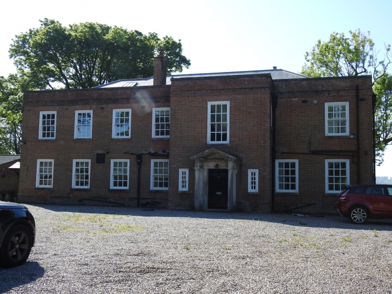
Large country house in neo-Georgian style. Walls of narrow brick in mostly Flemish bond with some ashlar dressings; low pitched hipped slate roof with narrow brick stacks behind parapet with ashlar coping with cone or orb finials. Windows are large 12-pane sashes in exposed moulded frames with rubbed brick voussoirs and shallow stone sills. Platband cornice with parapet gutter openings below; plinth. Garden frontage has a 7-window range with tall central ground floor stone doorway with architrave and segmental arched pediment on consoles, glazed door. This opens onto 2 semicircular steps leading to wide terrace with low walls of rubble and rock-faced stone with flat ashlar coping and steps to lawns flanked by stone piers with tall urns. Stepped back to right is the blind bay of the side elevation with added conservatory. Entrance elevation to rear has entrance bay stepped forward at centre right with classical stone portico with triglyph frieze, Doric columns and open pediment, panelled stone soffit, double doors incorporating boar's head motif in relief; the doorway is flanked by narrow 8-pane sashes to hall; large sash staircase window above. A 4-window range to left, 2 to right, though single window at first floor right.
Interior believed to retain original layout with the rear entrance and staircase hall connecting through pillars with the central garden hall. Reception rooms with garden frontages believed to retain original fireplaces in various styles (Georgian including Adam and C17), moulded plaster cornices, polished wood or parquet floors.
Listed for its special architectural interest as a fine neo-Georgian country house which has retained its character.
External links are from the relevant listing authority and, where applicable, Wikidata. Wikidata IDs may be related buildings as well as this specific building. If you want to add or update a link, you will need to do so by editing the Wikidata entry.


Other nearby listed buildings
