History in Structure

Ffynnon Fawr

A Grade II Listed Building in Porthcawl, Bridgend

More Photos »
Approximate Location Map
Large Map »

Coordinates

Latitude: 51.4894 / 51°29'21"N

Longitude: -3.6977 / 3°41'51"W

OS Eastings: 282225

OS Northings: 178086

OS Grid: SS822780

Mapcode National: GBR H7.KGLP

Mapcode Global: VH5HG.VTJL

Plus Code: 9C3RF8Q2+QW

Entry Name: Ffynnon Fawr

Listing Date: 21 February 2003

Last Amended: 21 February 2003

Grade: II

Source: Cadw

Source ID: 80911

Building Class: Water Supply and Drainage

ID on this website: 300080911

Location: To NW of roundabout at junction of A4106 and A4229.

County: Bridgend

Community: Porthcawl

Community: Porthcawl

Locality: Nottage

Traditional County: Glamorgan

Tagged with: Architectural structure

Find accommodation in
Porthcawl

History

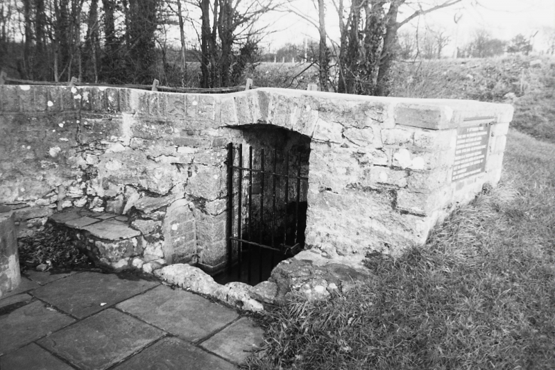
Although the well has an ancient history, the date of the present well-house is uncertain, and may be from the early C19.

Exterior

Rectangular well house in grey stone. Camber-headed doorway with iron gate, and steps down to vaulted cistern. To L, stone step (or seat?). On R side, plaque has inscriptions in Welsh and English:-

"Y Fynnon Fawr"

"Mae Dwr Yn Fendith Angenreidol
Rhoddes Duw Inni Ar Lawr;
Cofiwyn 'Awdur Pob Daioni'
Wrth Yfed Dwr O 'r Fynnon Fawr'

"Water Is A Necessary Blessing
Which God Has Given Us On Earth;
Let Us Remember 'The Author Of All Goodness'
As We Drink From Fynnon Fawr".

External Links

External links are from the relevant listing authority and, where applicable, Wikidata. Wikidata IDs may be related buildings as well as this specific building. If you want to add or update a link, you will need to do so by editing the Wikidata entry.

Recommended Books

Other nearby listed buildings

  • II Nottage House
    In a prominent position on the hillside just above the main roundabout on the N outskirts of Porthcawl and a little S of Nottage village centre; reached by a short drive.
  • II* Nottage Court
    On the E edge of the hamlet of Nottage, on rising ground above the valley of Dewiscumbe, set in large walled grounds reached by a drive.
  • II The Farmers' Arms
    Near the centre of the old village and backing onto the Village Green.
  • II Veronica Cottage
    In the centre of the old village, side on to the main village thoroughfare, fronting a garden and backing directly onto a lane.
  • II St David's Well aka Ffynnon Dewi
    By the side of the lane leading north from Nottage village just S of the junction with Moor Lane, both country lanes pre-dating C19 development and now little used.
  • II Former Tramroad and Railway bridge over Moor Lane
    A short distance due N of Nottage village centre, near the junction of the village lane and Moor Lane by St David's Well.
  • II Newton Primary School (2 blocks)
    Situated E of Porthcawl centre and harbour, W of Newton village, on the main road linking the two, by junction of the sea road to Sandy Bay.
  • II Tabernacl Capel yr Annibynwyr aka Welsh Congregational Chapel
    Just N of the main centre of Porthcawl town in a residential street W of the main N/S thoroughfare of South Road.

BritishListedBuildings.co.uk is an independent online resource and is not associated with any government department. All government data published here is used under licence. Please do not contact BritishListedBuildings.co.uk for any queries related to any individual listed building, planning permission related to listed buildings or the listing process itself.

British Listed Buildings is a Good Stuff website.