Approximate Location Map
Large Map »
Latitude: 51.7778 / 51°46'40"N
Longitude: -2.9874 / 2°59'14"W
OS Eastings: 331975
OS Northings: 209254
OS Grid: SO319092
Mapcode National: GBR F6.Z5MQ
Mapcode Global: VH79F.5KKZ
Plus Code: 9C3VQ2H7+42
Entry Name: The Old Schoolhouse
Listing Date: 9 December 2005
Last Amended: 9 December 2005
Grade: II
Source: Cadw
Source ID: 87165
Building Class: Domestic
ID on this website: 300087165
Location: About 500m south of the Church of St. Bartholomew on the east side of the road from Llanellen to Llanfair Kilgeddin.
County: Monmouthshire
Town: Abergavenny
Community: Llanover (Llanofer)
Community: Llanover
Traditional County: Monmouthshire
Tagged with: School building
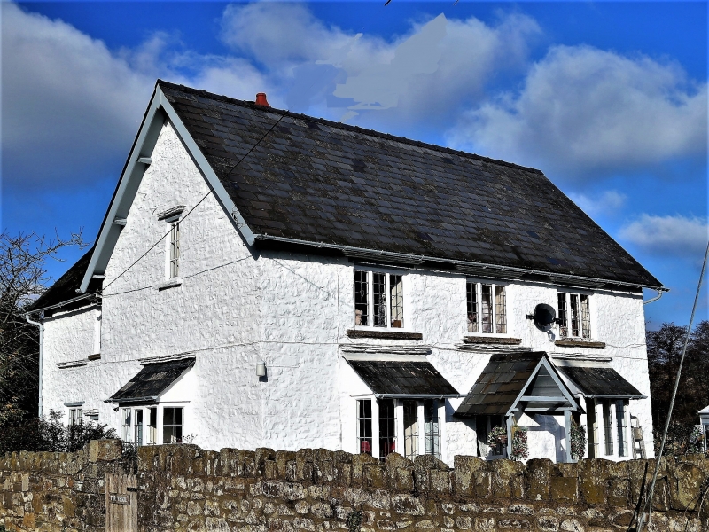
This building was probably especially built as the Llanover parish schoolmaster's house, which it was from 1835 when the school moved from the tower of St. Bartholomew's Church (qv); until the present school was built at Tre-elidyr (qv) in 1925.
Built of roughly coursed local rubblestone which is completely painted over, natural slate roof and red brick stack. Picturesque gabled style. T-shaped plan, two storeys. Three bay central entrance elevation with gabled wing to rear. Part-glazed door with gabled porch. This is flanked by 3-light bays with pent slate roofs; three 3-light windows above, with straight stone drips, all windows are early C20. Plain steeply pitched roof. Left return gable has another bay window on the ground floor with a casement window above. Wing to rear right has two windows both 2-light small paned casements on the ground floor, but of different sizes, only one above. The gable end of the wing has another bay as before and three other windows all with drips over. Steeply pitched roof with projecting eaves and ridge stack.
Rear elevation not seen.
Interior not available at resurvey.
Included for its special interest as part of the estate school in the C19 built for the children of the Llanover Estate workers. The house retains good picturesque character.
External links are from the relevant listing authority and, where applicable, Wikidata. Wikidata IDs may be related buildings as well as this specific building. If you want to add or update a link, you will need to do so by editing the Wikidata entry.


Other nearby listed buildings
