Approximate Location Map
Large Map »
Latitude: 53.915 / 53°54'53"N
Longitude: -1.141 / 1°8'27"W
OS Eastings: 456521
OS Northings: 446875
OS Grid: SE565468
Mapcode National: GBR NRG5.SB
Mapcode Global: WHDB4.FVXL
Plus Code: 9C5WWV75+XJ
Entry Name: Church of St Giles
Listing Date: 23 August 1978
Grade: II
Source: Historic England
Source ID: 1166793
English Heritage Legacy ID: 325960
ID on this website: 101166793
Location: St Giles's Church, Copmanthorpe, York, North Yorkshire, YO23
County: York
Civil Parish: Copmanthorpe
Built-Up Area: Copmanthorpe
Traditional County: Yorkshire
Lieutenancy Area (Ceremonial County): North Yorkshire
Church of England Parish: Copmanthorpe St Giles
Church of England Diocese: York
Tagged with: Church building
SE 54 NE COPMANTHORPE CHURCH STREET
(north side)
3/44 Church of St Giles
- II
23.8.78
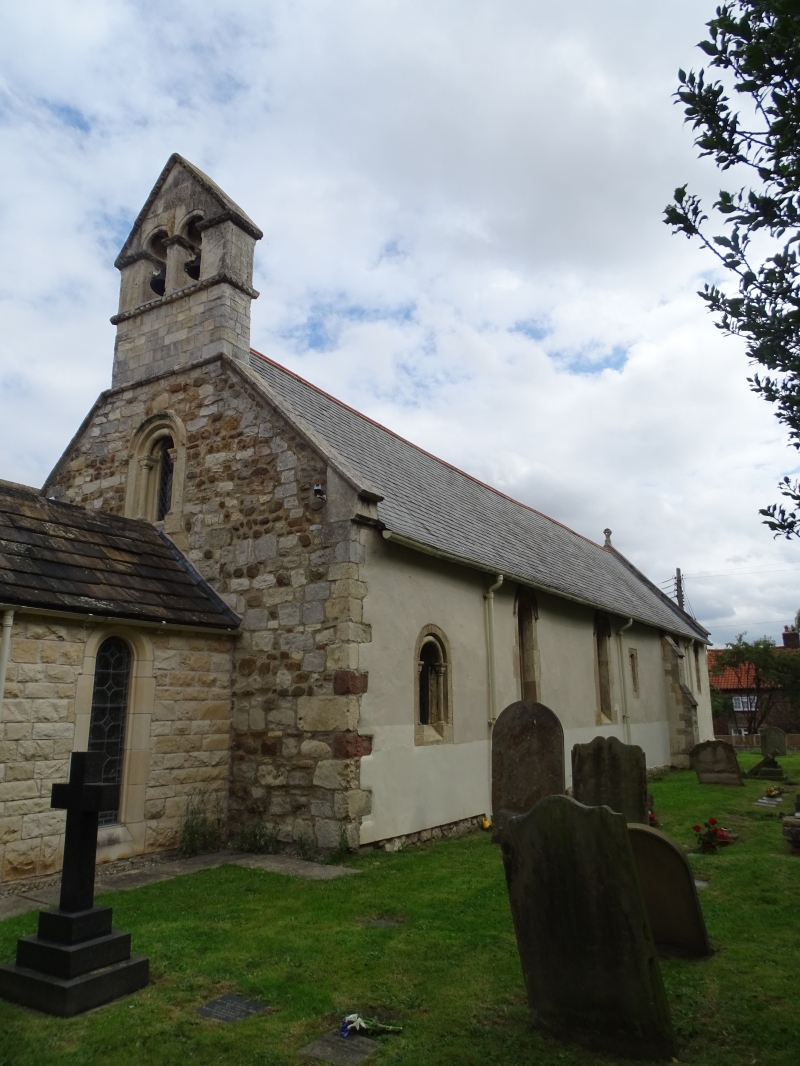
Church. C12 much altered with chancel of 1889 and C20 additions including
west porch. Magnesian limestone ashlar, partly rendered and colourwashed,
brick outshut and Welsh slate roof. West porch, nave and chancel in one,
C20 parish rooms and outshut to north. Porch contains C12 doorway with
chamfered surround and single nook shaft with scalloped capitals supporting
arch with ball moulding. C12 bell-turret with twin round-arched openings.
Nave and chancel: south side, buttress with offsets between. Mainly single
round-headed windows in chamfered surrounds, those to nave under recut hood-
moulds, the west-most with single nook shafts supporting roll moulding.
One slit window. North side: 2 similar round-headed windows, otherwide
obscured by outshut and parish rooms. East end said to be C12 reconstructed
to end of C19 extension. Group of 3 stepped round-arched windows in
chamfered surround under hood-mould. Interior: glass to east window by
Kempe, c1889. N Pevsner, Yorkshire, The West Riding, 1979, p 171.
Listing NGR: SE5652146875
External links are from the relevant listing authority and, where applicable, Wikidata. Wikidata IDs may be related buildings as well as this specific building. If you want to add or update a link, you will need to do so by editing the Wikidata entry.


Other nearby listed buildings
