Approximate Location Map
Large Map »
Latitude: 50.3516 / 50°21'5"N
Longitude: -3.5805 / 3°34'49"W
OS Eastings: 287652
OS Northings: 51380
OS Grid: SX876513
Mapcode National: GBR QS.R9QQ
Mapcode Global: FRA 38D3.LWF
Plus Code: 9C2R9C29+JQ
Entry Name: Horse Trough Approximately 2 Metres to West of Pannier Market, Market Square
Listing Date: 23 February 1994
Grade: II
Source: Historic England
Source ID: 1208308
English Heritage Legacy ID: 387188
ID on this website: 101208308
Location: Dartmouth, South Hams, Devon, TQ6
County: Devon
District: South Hams
Civil Parish: Dartmouth
Built-Up Area: Dartmouth
Traditional County: Devon
Lieutenancy Area (Ceremonial County): Devon
Church of England Parish: Dartmouth Townstal
Church of England Diocese: Exeter
Tagged with: Watering trough Drinking fountain
DARTMOUTH
SX874510 CHARLES STREET
673-1/8/60 (East side)
Horse trough approximately 2 metres
to west of Pannier Market, Market
Square
GV II
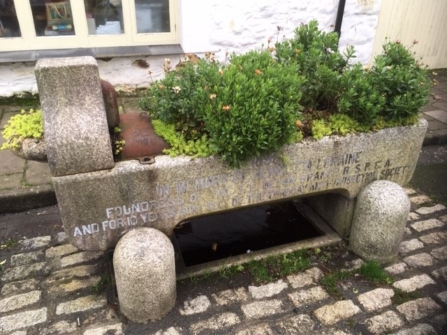
Horse trough with drinking fountain. Dated 1898. Granite
ashlar. Trough rests on 2 squared blocks of granite. Bottom
edges chamfered between the supporting blocks and projecting
end is rounded. Granite bollards against the feet on the
street side to protect it from the traffic. Left (north) end
rises with ogee curves to house water pipes and, on the outer
side, a small ornately-cast tap remains to a semi-circular
basin, the drinking fountain.
The road front is set with lead letters which record that the
trough was erected in 1898 in memory of Henrietta Loraine, a
founder member of the SE Devon branch of the RSPCA and, for 10
years, secretary of the Torquay Anti-Vivisection Society.
Included for group value.
Listing NGR: SX8765251380
External links are from the relevant listing authority and, where applicable, Wikidata. Wikidata IDs may be related buildings as well as this specific building. If you want to add or update a link, you will need to do so by editing the Wikidata entry.


Other nearby listed buildings
