Approximate Location Map
Large Map »
Latitude: 53.2814 / 53°16'52"N
Longitude: -4.5631 / 4°33'47"W
OS Eastings: 229220
OS Northings: 379109
OS Grid: SH292791
Mapcode National: GBR HN30.W0Y
Mapcode Global: WH42H.WS99
Plus Code: 9C5Q7CJP+HQ
Entry Name: Valley Station Signal Box
Listing Date: 19 January 1998
Last Amended: 19 January 1998
Grade: II
Source: Cadw
Source ID: 19233
Building Class: Transport
ID on this website: 300019233
Location: Located at the S end of Valley, directly NW of the level crossing on the B4545.
County: Isle of Anglesey
Community: Valley (Y Fali)
Community: Valley
Built-Up Area: Valley
Traditional County: Anglesey
Tagged with: Signal box
Probably built mid C19. In December 1867 the 'way and works' committee ordered that the 'block' telegraph be installed between Chester and Saltney and in February 1869 the train telegraph ordered for the remainder of the Chester to Holyhead Railway, including 15 new huts at a total cost of £3,450. In 1870 it was ruled that the 'absolute block' system be adopted on the CHR immediately and in 1871, that all points on the line be interlocked, the 'speaking' telegraph was ordered for the line the following year.
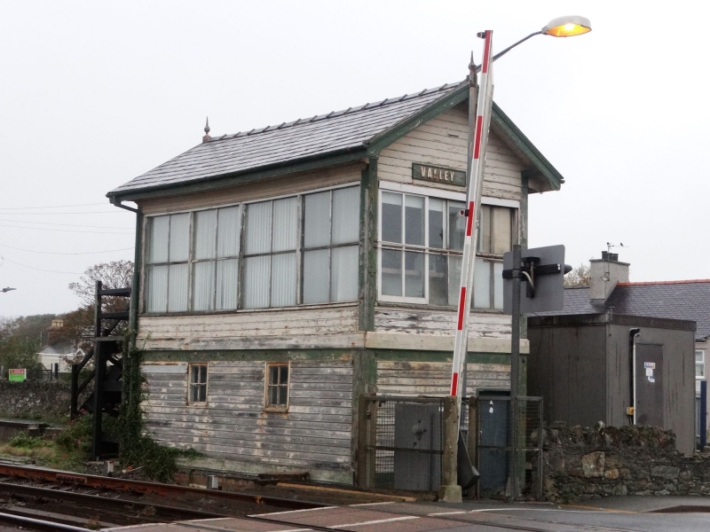
A 2-storey, timber built signal box, clad with horizontal tongued and grooved panelling and with large, horizontally-sliding sash windows on three sides to upper storey; lower storey with 4-pane fixed lights. Slate roof with projecting eaves and verges, plain bargeboards with pointed gable apex finials.
Unaltered and retains lever frames.
Included as a well-preserved example of a timber-built Signal Box; forming a group with Valley Railway Station.
External links are from the relevant listing authority and, where applicable, Wikidata. Wikidata IDs may be related buildings as well as this specific building. If you want to add or update a link, you will need to do so by editing the Wikidata entry.


Other nearby listed buildings
