Approximate Location Map
Large Map »
Latitude: 51.8132 / 51°48'47"N
Longitude: -2.7103 / 2°42'37"W
OS Eastings: 351127
OS Northings: 212967
OS Grid: SO511129
Mapcode National: GBR FL.WVQZ
Mapcode Global: VH86T.ZP0C
Plus Code: 9C3VR77Q+7V
Entry Name: The Old Nag's Head P H
Listing Date: 26 April 1955
Last Amended: 10 August 2005
Grade: II*
Source: Cadw
Source ID: 2312
Building Class: Defence
Also known as: The Old Nag's Head
Old Nags Head
The Old Nags Head, Monmouth
ID on this website: 300002312
Location: On the historic north and east entry to the town, but now a cul-de-sac.
County: Monmouthshire
Town: Monmouth
Community: Monmouth (Trefynwy)
Community: Monmouth
Built-Up Area: Monmouth
Traditional County: Monmouthshire
Tagged with: Pub
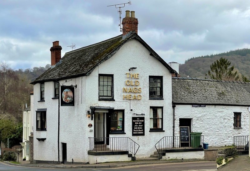
Early C19, but incorporating in its structure remains of a tower of the eastern or Dixton Gate of the town. The medieval work is probably C15 and how much fabric from this date may survive in the present building is unknown. The Dixton Gate was otherwise demolished probably in the C18 and was replaced by the turnpike gate further down the street.
The medieval fabric is red sandstone rubble, the C19 fabric is probably also red sandstone but may be brick, particularly in the upper storey. The tower remains unpainted, the inn is rendered and painted and the south-east wing of the inn, formerly the stable, is painted rubble; Welsh slate roofs with red brick stacks. Main rectangular block with the half round tower on the north gable, east wing projecting from south-east corner. Two storeys with an understorey, the tower has a battered base. The entry to the main block is in the gable end and has a recessed door on the left with a flat hood on brackets. Two windows on each floor, all 4 over 4 pane sashes except at top left which is 6 over 6. Gable with wavey bargeboards. The street front has a small cellar door, a plate glass oriel on the ground floor left and two 6 over 6 pane sashes left above. Plain roof with stack on left wall front slope and another on right gable. The tower has a 6 over 6 pane sash on the ground floor and an 8 over 8 above. Small casement in timber framed gable of main block behind. The east wing, formerly the stable, has a plain door and a 2 x 2 light casement window, plain roof. Rear elevation not seen.
Only the ground floor was seen at resurvey, no pre-C19 fabric is visible.
Included in a higher grade for its interest as an early C19 public house which retains its character as well as a significant portion of a medieval gate-tower.
External links are from the relevant listing authority and, where applicable, Wikidata. Wikidata IDs may be related buildings as well as this specific building. If you want to add or update a link, you will need to do so by editing the Wikidata entry.


Other nearby listed buildings
