Approximate Location Map
Large Map »
Latitude: 50.8356 / 50°50'8"N
Longitude: -0.7792 / 0°46'45"W
OS Eastings: 486060
OS Northings: 104721
OS Grid: SU860047
Mapcode National: GBR DGS.FV1
Mapcode Global: FRA 968W.L7S
Plus Code: 9C2XR6PC+78
Entry Name: 61, South Street
Listing Date: 5 July 1950
Grade: II
Source: Historic England
Source ID: 1026618
English Heritage Legacy ID: 300196
ID on this website: 101026618
Location: The Close, Chichester, West Sussex, PO19
County: West Sussex
District: Chichester
Civil Parish: Chichester
Built-Up Area: Chichester
Traditional County: Sussex
Lieutenancy Area (Ceremonial County): West Sussex
Church of England Parish: Chichester St Paul
Church of England Diocese: Chichester
Tagged with: House
This list entry was subject to a Minor Amendment on 30 June 2022 to update the name and address and to reformat the text to current standards
SU 8604 NW
4/80
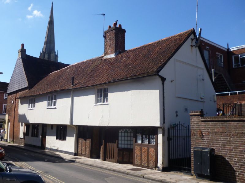
SOUTH STREET (east side)
No 61
(Formerly listed as No 61 (The White Horse))
5.7.50
II
C18 with medieval timber-framed wing. Two storeys and attic. Steeply pitched tiled gabled roof. Three flat roofed dormers. Red brick front. Above first floor windows narrow brick stringcourse, brick paterae and finally red brick dentilled cornice below eaves. Four window bays. Sash windows in reveals in flat arches with rubbed brick voussoirs; glazing bars intact. Public house front on ground floor. Large round-headed doorway with heavy pediment and massive consoles. Modern door with stained glass head to it. Projecting iron arm over the street for the sign with a bunch of grapes dangling from it. The back part in West Pallant consists of a range of cottages with plaster front and first floor overhanging.
Listing NGR: SU8606804720
External links are from the relevant listing authority and, where applicable, Wikidata. Wikidata IDs may be related buildings as well as this specific building. If you want to add or update a link, you will need to do so by editing the Wikidata entry.


Other nearby listed buildings
