Approximate Location Map
Large Map »
Latitude: 51.3331 / 51°19'59"N
Longitude: 0.7416 / 0°44'29"E
OS Eastings: 591084
OS Northings: 162898
OS Grid: TQ910628
Mapcode National: GBR RTD.8BT
Mapcode Global: VHKJL.SRYF
Plus Code: 9F328PMR+6M
Entry Name: Chilton Manor
Listing Date: 13 December 1974
Grade: II
Source: Historic England
Source ID: 1031372
English Heritage Legacy ID: 175796
ID on this website: 101031372
Location: Sittingbourne, Swale, Kent, ME10
County: Kent
District: Swale
Electoral Ward/Division: Woodstock
Parish: Non Civil Parish
Built-Up Area: Sittingbourne
Traditional County: Kent
Lieutenancy Area (Ceremonial County): Kent
Tagged with: Manor house
1.
5282 HIGHSTED ROAD
(East Side)
SITTINGBOURNE
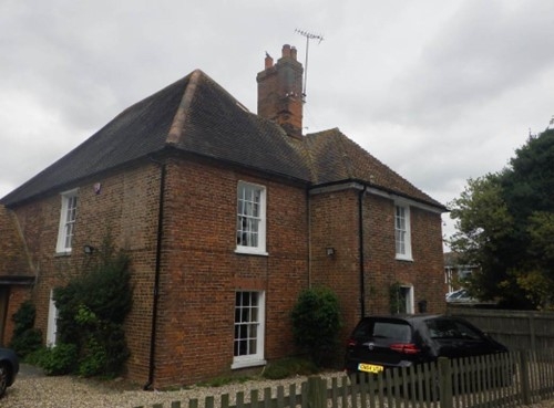
Chilton Manor
TQ 96 SW 9/35
II
2.
An Cl8 house altered in the Cl9. 2 storeys red brick, Hipped tiled roof. 7 sashes
with glazing bars intact. Victorian projection and gable in the centre of the
West front. Original projection on the East.
Listing NGR: TQ9108462898
External links are from the relevant listing authority and, where applicable, Wikidata. Wikidata IDs may be related buildings as well as this specific building. If you want to add or update a link, you will need to do so by editing the Wikidata entry.


Other nearby listed buildings
