Approximate Location Map
Large Map »
Latitude: 51.1715 / 51°10'17"N
Longitude: -2.1195 / 2°7'10"W
OS Eastings: 391740
OS Northings: 141369
OS Grid: ST917413
Mapcode National: GBR 1VN.JY2
Mapcode Global: VH97Q.6TV9
Plus Code: 9C3V5VCJ+J5
Entry Name: 188 Tytherington
Listing Date: 1 July 1986
Grade: II
Source: Historic England
Source ID: 1036376
English Heritage Legacy ID: 313326
ID on this website: 101036376
Location: Tytherington, Wiltshire, BA12
County: Wiltshire
Civil Parish: Heytesbury
Traditional County: Wiltshire
Lieutenancy Area (Ceremonial County): Wiltshire
Church of England Parish: Heytesbury with Tytherington and Knook St Peter and St Paul
Church of England Diocese: Salisbury
Tagged with: Building Thatched cottage
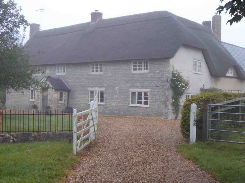
HEYTESBURY TYTHERINGTON VILLAGE (west side)
ST 94 SW 4/105
No. 188
GV II
Three semi-detached cottages, now one house. Early C17, rebuilt and refronted 1747. 'L'-plan; main range has through passage to left of central stack. Timber-framing, refronted in rubble stone, thatched roof, brick stacks. Two storey, 4-windowed; casements. Planked door in gabled porch to left of centre, C19 three-light casement to left and two to right. First floor has four 3-light casements and datestone incised with TE/1747 to left of door. Right and left returns rendered, right return of C17 single storey
timber-framed extension has 3-light casement to ground floor and 2-light casement to eyebrow dormer. Rear of main range has planked door to left, two C20 casements to right, wall plate with mortices on soffit, of former timber-framed wall is retained above rubble stone facing. Extension is also partly rebuilt in stone with planked door and 2-light casements to eyebrow dormers, rear gable has pair of diagonally-set brick stacks, coped verge. Interior has deeply chamfered beams with stepped stops; west beam on stone corbel in passage, wing has beam with narrower chamfers and ogee stops, blocked open fireplaces, planked doors with strap hinges, roof not accessible but said to be intact. This house represents an unusual survival of the through passage plan in this area; the hall was to the right of the passage, separated by a rubble stone wall which supports the main stack of the now blocked open fireplace backing onto the passage, services were to the left of the passage and additional accommodation was provided by the square timber-framed extension in later C17.
Listing NGR: ST9174041369
External links are from the relevant listing authority and, where applicable, Wikidata. Wikidata IDs may be related buildings as well as this specific building. If you want to add or update a link, you will need to do so by editing the Wikidata entry.


Other nearby listed buildings
