Approximate Location Map
Large Map »
Latitude: 52.0604 / 52°3'37"N
Longitude: 1.1595 / 1°9'34"E
OS Eastings: 616686
OS Northings: 244938
OS Grid: TM166449
Mapcode National: GBR TMP.ZYR
Mapcode Global: VHLBT.1GVV
Plus Code: 9F433565+5R
Entry Name: 44, Bolton Lane
Listing Date: 4 August 1972
Grade: II
Source: Historic England
Source ID: 1037751
English Heritage Legacy ID: 275399
ID on this website: 101037751
Location: Ipswich, Suffolk, IP4
County: Suffolk
District: Ipswich
Electoral Ward/Division: St Margaret's
Parish: Non Civil Parish
Built-Up Area: Ipswich
Traditional County: Suffolk
Lieutenancy Area (Ceremonial County): Suffolk
Church of England Parish: Ipswich St Margaret
Church of England Diocese: St.Edmundsbury and Ipswich
Tagged with: Building
1.
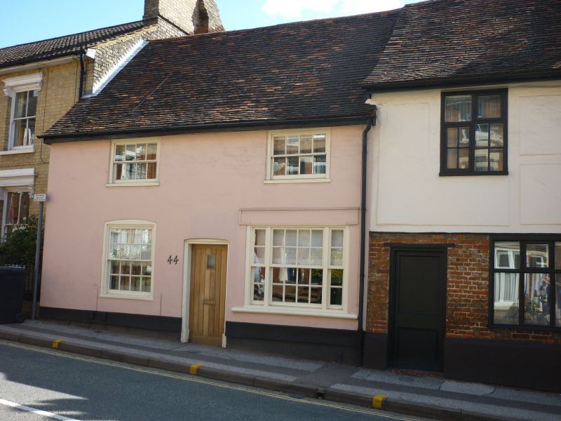
1260 BOLTON LANE
No 44
TM 1644 NE 2/259
II GV
2.
A late C18 or early C19 red brick front, probably to an earlier C17 building
adjoining Nos 40 and 42. 2 storeys. 2 window range, double-hung sashes
with glazing bars, in plain reveals. The ground storey has a C19 shop window.
Roof tiled.
Nos 40 to 44 (even) form a group.
Listing NGR: TM1668644938
External links are from the relevant listing authority and, where applicable, Wikidata. Wikidata IDs may be related buildings as well as this specific building. If you want to add or update a link, you will need to do so by editing the Wikidata entry.


Other nearby listed buildings
