Approximate Location Map
Large Map »
Latitude: 51.7576 / 51°45'27"N
Longitude: -1.2604 / 1°15'37"W
OS Eastings: 451146
OS Northings: 206807
OS Grid: SP511068
Mapcode National: GBR 8YY.L6H
Mapcode Global: VHCXV.32JY
Plus Code: 9C3WQP5Q+2R
Entry Name: Stone Outside Number 42 St Giles Street
Listing Date: 28 June 1972
Grade: II
Source: Historic England
Source ID: 1046585
English Heritage Legacy ID: 245248
ID on this website: 101046585
Location: Norham Manor, Oxford, Oxfordshire, OX1
County: Oxfordshire
District: Oxford
Electoral Ward/Division: Carfax
Parish: Non Civil Parish
Built-Up Area: Oxford
Traditional County: Oxfordshire
Lieutenancy Area (Ceremonial County): Oxfordshire
Church of England Parish: Oxford St Giles
Church of England Diocese: Oxford
Tagged with: Building Boundary marker
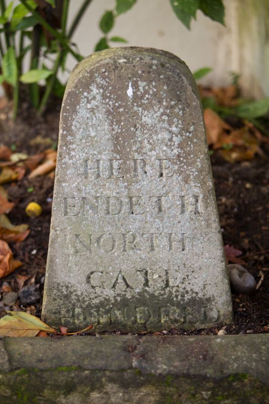
INSCRIBED STONES
1.
1485
Hundred stones
Stone outside
No 42 St Giles'
Street
SP 5106 NW 5/740
II
2.
An ancient stone with the worn inscription 'Here endeth North Gate Hundred'.
Listing NGR: SP5114206823
External links are from the relevant listing authority and, where applicable, Wikidata. Wikidata IDs may be related buildings as well as this specific building. If you want to add or update a link, you will need to do so by editing the Wikidata entry.


Other nearby listed buildings
