Approximate Location Map
Large Map »
Latitude: 51.0947 / 51°5'40"N
Longitude: 0.5392 / 0°32'21"E
OS Eastings: 577899
OS Northings: 135886
OS Grid: TQ778358
Mapcode National: GBR PTC.C3W
Mapcode Global: FRA D607.9VS
Plus Code: 9F323GVQ+VM
Entry Name: 1, Tippens Close
Listing Date: 19 May 1986
Grade: II
Source: Historic England
Source ID: 1051674
English Heritage Legacy ID: 169137
ID on this website: 101051674
Location: Cranbrook, Tunbridge Wells, Kent, TN17
County: Kent
District: Tunbridge Wells
Civil Parish: Cranbrook & Sissinghurst
Built-Up Area: Cranbrook
Traditional County: Kent
Lieutenancy Area (Ceremonial County): Kent
Tagged with: Building
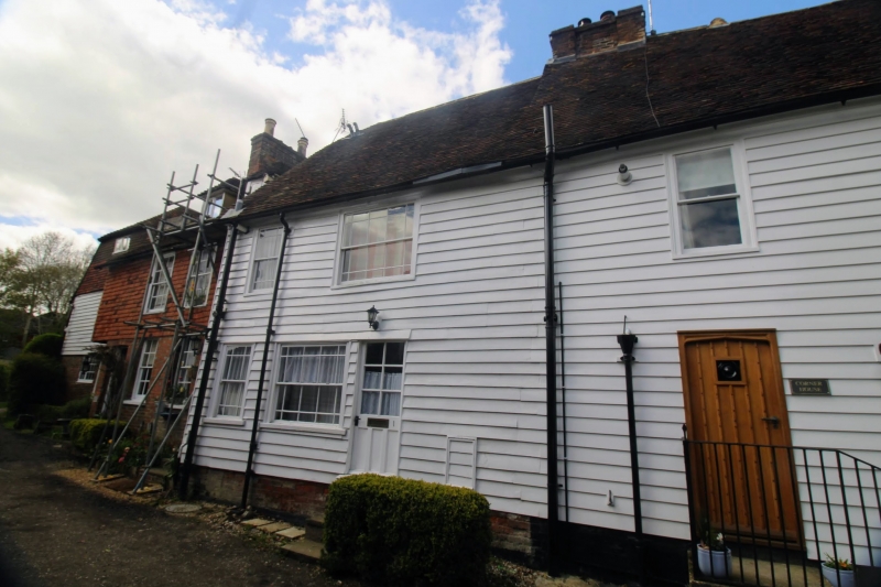
CRANBROOK TIPPENS CLOSE
TQ 7735 NE
(north side)
12/286
- No 1
GV II
Cottage, possibly former wing at rear of The Corner House (gv The Hill, south
west side). C17. Timber framed on red brick plinth and weatherboarded.
Painted brick side to left on ground floor, tile-hung above. Plain tiled
gambrel roof. 2 storeys and garret. 2 window front, margin-light sashes,
those in right-hand bay wider. Half glazed door to right.
Listing NGR: TQ7790335884
External links are from the relevant listing authority and, where applicable, Wikidata. Wikidata IDs may be related buildings as well as this specific building. If you want to add or update a link, you will need to do so by editing the Wikidata entry.


Other nearby listed buildings
